 Filter: Categories of Wisconsin Historical Images
Filter: State of Virginia
Filter: Subject of dwellings
Filter: Subject of land
Filter: Categories of Wisconsin Historical Images
Filter: State of Virginia
Filter: Subject of dwellings
Filter: Subject of land
| Date: | 1922 |
|---|---|
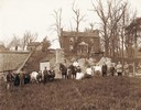
| Description: | Harold F. McCormick family, farm laborers, and various animals on the Walnut Grove estate at Raphine, Virginia. Harold McCormick was the son of Cyrus Hall ... |
| Date: | 1900 |
|---|---|
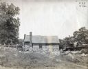
| Description: | Exterior view of the family farm, Walnut Grove, of Robert Hall McCormick (father of Cyrus Hall McCormick). |
| Date: | |
|---|---|
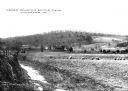
| Description: | A view of the Cedar Mountain Battlefield. Caption reads: "Cedar Mountain Battle Field, Culpeper, VA." |
| Date: | |
|---|---|
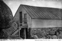
| Description: | Exterior of Peaks of Otter Lodge. The wooden shelter, built into the surrounding rock, features a doorway in the stone, ground floor, and one in the wooden... |

| Date: | |
|---|---|
| Description: | A hand-drawn map of Indian boundary lines in southwest Virginia. It also includes the Duck River and the Elk River. |

| Date: | |
|---|---|
| Description: | Elevated view of a colony of residences in a mountain setting. |

| Date: | |
|---|---|
| Description: | Elevated view of the Blue Ridge Terrace, a large hotel on a mountain overlooking the valley. Cars are parked near the road, and three men are gathered on t... |

| Date: | |
|---|---|
| Description: | View down hill toward the York River with small homes on its banks. Long piers stretch into the river. |

| Date: | 1863 |
|---|---|
| Description: | This map shows roads, railroads, settlements, farms with owners' names, vegetation, streams, and fords in Culpeper County region during the Civil War. A ma... |

| Date: | 1864 |
|---|---|
| Description: | This map of the area of the First Battle of Bull Run shows military positions and troop movements as well as the names of landowners, vegetation and land u... |

| Date: | 1864 |
|---|---|
| Description: | This map created during the Civil War indicates Confederate fortifications, houses, names of residents, towns, roads, railroads, relief by hachures, draina... |

| Date: | 1865 |
|---|---|
| Description: | This detailed map of the area between Richmond and Petersburg shows fortifications, roads, railroads, towns, street patterns of Petersburg and Richmond, dr... |

| Date: | 1865 |
|---|---|
| Description: | The map of the battlefield shows entrenchments, villages, roads, the "South Side Rail Road" drainage, vegetation, relief by hachures, houses, and names of ... |

| Date: | 05 07 1928 |
|---|---|
| Description: | View looking downhill toward the side of a log building with stone foundation built into the side of a hill at Walnut Grove. A path is on the left leading ... |
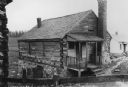
| Date: | 05 07 1928 |
|---|---|
| Description: | View over wood fence looking down towards the front and left side of a log building with a peaked roof, second story, and a stone foundation built into the... |
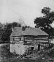
| Date: | 1928 |
|---|---|
| Description: | View down hill looking towards the side and back of a log building with stone foundation built into the side of a hill. Smoke is rising from the chimney ex... |
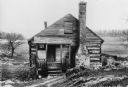
| Date: | 05 07 1928 |
|---|---|
| Description: | View looking down towards the front of a log building built into the side of a hill. A small roofed porch with a window and door is on the left, and an ext... |
| Date: | |
|---|---|
| Description: | View looking up towards the manor house on a hill at the Walnut Grove farm. In the foreground below are fences and a small building with an external chimne... |

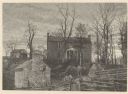
| Date: | |
|---|---|
| Description: | View toward the entrance to the manor house at Walnut Grove. A fence surrounds the house, and a man is standing near an automobile parked on the left behin... |

| Date: | |
|---|---|
| Description: | View across farm towards the house on the hill in the distance on the right. A fenced garden with a shed is in the center, and behind it are two small farm... |
If you didn't find the material you searched for, our Library Reference Staff can help.
Call our reference desk at 608-264-6535 or email us at: