 Filter: Categories of Wisconsin Historical Images
Filter: State of Virginia
Filter: Subject of dwellings
Filter: Year of 1800-1899
Filter: Categories of Wisconsin Historical Images
Filter: State of Virginia
Filter: Subject of dwellings
Filter: Year of 1800-1899
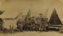
| Date: | 07 18 1862 |
|---|---|
| Description: | Officers of the Second Wisconsin Infantry posed in front of a tent. They are, from left to right, Quartermaster J.D. Ruggles, Dr. A.J. Ward, Major J.S. All... |
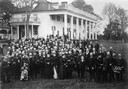
| Date: | 1890 |
|---|---|
| Description: | Slightly elevated view of the members of the United States Pharmacopeial Convention and their families standing for a portrait at Mount Vernon. |
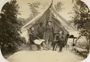
| Date: | 1862 |
|---|---|
| Description: | Officers of Company I, 7th Wisconsin Infantry: (left to right) Lt. Joseph N.P. Bird, Captain George H. Walther, and Lt. Christopher Lefler. Their Black ser... |
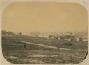
| Date: | 06 1862 |
|---|---|
| Description: | The 7th Wisconsin Volunteer Infantry Regiment camp outside of Fredericksburg on the east side of the Rappahannock. Fredericksburg and a pontoon bridge lea... |
| Date: | 1862 |
|---|---|
| Description: | "Camp Casey near Fairfax Seminary, Virginia 1st Brigade, Casey's Division". Handcolored lithograph of site of Camp Casey. |

| Date: | 1862 |
|---|---|
| Description: | Non-commissioned officers of Company C of the 2nd Wisconsin. From left to right they are W.S. Rouse, R. Ash, G.E. Smith, N.H. Whittemore, O.F. Crary, and J... |

| Date: | 1880 |
|---|---|
| Description: | James Dorman Davidson (1810-1882) sits in profile in a plush chair for a studio portrait in front of a backdrop. He is wearing a wide hat, suit jacket, bow... |
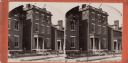
| Date: | 1864 |
|---|---|
| Description: | Marshall House, in which Col. E.E. Ellsworth was shot on May 24, 1861. |
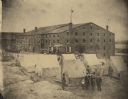
| Date: | 1864 |
|---|---|
| Description: | Exterior view of Libby Prison, a Confederate Prison. The view includes tents and three tenement (loft style) buildings. A group of men stand in the foregro... |
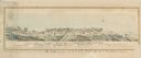
| Date: | 1863 |
|---|---|
| Description: | A heavily retouched photographic view of Libby Prison. This view shows tents and three tenement (loft style) buildings. |
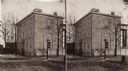
| Date: | 1864 |
|---|---|
| Description: | A stereograph of exterior of General Lee's residence. |
| Date: | 1871 |
|---|---|
| Description: | Stereograph of exterior of a building used as the Confederate government's Executive Mansion. This was where Jefferson Davis and his family stayed during t... |
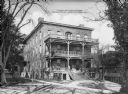
| Date: | 1872 |
|---|---|
| Description: | A view of the female residence at Hampton Institute. The left side of the front porch contains potted plant,s and three women converse near the steps. Anot... |
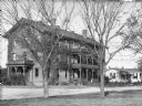
| Date: | 1878 |
|---|---|
| Description: | A view of the Native American male dormitory, called "Wigwam." The structure has three floors, each with a balcony. A smaller building is next to it on the... |
| Date: | 1872 |
|---|---|
| Description: | Female students garden next to the Home Economics Practice House. The house has clapboard siding on its two stories and there is a porch on the front and b... |

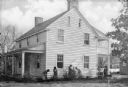
| Date: | 1880 |
|---|---|
| Description: | Interior view of Washington and Lee University chapel showing tomb of Robert E. Lee. Portraits hang on the wall around an arch leading to the tomb. |

| Date: | 1863 |
|---|---|
| Description: | This map shows roads, railroads, settlements, farms with owners' names, vegetation, streams, and fords in Culpeper County region during the Civil War. A ma... |

| Date: | 1864 |
|---|---|
| Description: | This map of the area of the First Battle of Bull Run shows military positions and troop movements as well as the names of landowners, vegetation and land u... |

| Date: | 1864 |
|---|---|
| Description: | This map created during the Civil War indicates Confederate fortifications, houses, names of residents, towns, roads, railroads, relief by hachures, draina... |

| Date: | 1865 |
|---|---|
| Description: | This detailed map of the area between Richmond and Petersburg shows fortifications, roads, railroads, towns, street patterns of Petersburg and Richmond, dr... |
If you didn't find the material you searched for, our Library Reference Staff can help.
Call our reference desk at 608-264-6535 or email us at: