Filter: Categories of Wisconsin Historical Images
Filter: State of Virginia
Filter: Subject of land use
Filter: Subject of cities and towns
Filter: Categories of Wisconsin Historical Images
Filter: State of Virginia
Filter: Subject of land use
Filter: Subject of cities and towns
| Date: | |
|---|---|
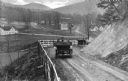
| Description: | Elevated view of two cars on a dirt road heading downhill. A town is in the valley below, and mountains are in the distance. |

| Date: | |
|---|---|
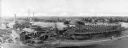
| Description: | An aerial view of the port and a section of the city showing a large boat, a railway depot, a park plaza and a grid of city streets with large buildings. |
| Date: | |
|---|---|
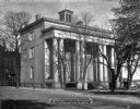
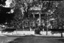
| Description: | View across street toward the Jefferson Davis mansion. Caption reads: "Jefferson Davis Mansion, now Confederate Museum." |
| Date: | 1864 |
|---|---|
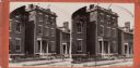
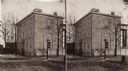
| Description: | A stereograph of exterior of General Lee's residence. |
| Date: | 1871 |
|---|---|
| Description: | Stereograph of exterior of a building used as the Confederate government's Executive Mansion. This was where Jefferson Davis and his family stayed during t... |

| Date: | |
|---|---|
| Description: | View across street toward the colonial court house. The brick structure has a cupola on the roof with a weather vane. |

| Date: | |
|---|---|
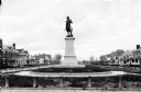
| Description: | A monument and statue honoring the Confederate general Thomas Jonathan "Stonewall" Jackson. There is a cemetery in the background on the left. |

| Date: | |
|---|---|
| Description: | View of an intersection of two dirt roads, East Market Street and Lafayette Street. A man, horseback, can be seen on the left, while two people walk past ... |
| Date: | |
|---|---|
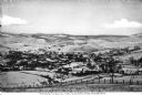
| Description: | Elevated view of the town and countryside, looking north. Published by Jackson's Pharmacy. |

| Date: | |
|---|---|
| Description: | View of a World War I Monument outside of the County Clerk's Office. To the left of the colonnaded Clerk's Office, the Old Courthouse, built in 1895, can ... |
| Date: | |
|---|---|
| Description: | View of Stuart Hall, a residential mansion used as the Virginia Female Institute. Chartered on January 13, 1744, the school is the state's oldest college p... |
| Date: | |
|---|---|
| Description: | Bronze statue of Hugh Mercer (1726-1777), Physician and Brigadier General of the Continental Army during the Revolutionary War. Mercer died of wound he rec... |

| Date: | |
|---|---|
| Description: | View of the Henry Clay Monument with a statue of Clay inside. In front stand two young girls wearing dresses. Each girl is holding a pet rabbit. On the rig... |

| Date: | 1770 |
|---|---|
| Description: | The south west sheet of a four sheet map of Virginia, showing the counties, mountains, rivers, court houses, a few cities, and mills. A few Plantations ar... |

| Date: | 1755 |
|---|---|
| Description: | Map of Virginia and parts of Maryland, North Carolina, and New Jersey. It shows borders, boundary lines, some Native American land, counties, cities, towns... |

| Date: | 1762 |
|---|---|
| Description: | Map of Virginia and parts of Maryland. It shows borders, boundary lines, Native American tribes and land, towns, forts, roads, mountains, waterfalls, bays,... |
If you didn't find the material you searched for, our Library Reference Staff can help.
Call our reference desk at 608-264-6535 or email us at: