 Filter: Categories of Wisconsin Historical Images
Filter: State of Virginia
Filter: Subject of landforms
Filter: Categories of Wisconsin Historical Images
Filter: State of Virginia
Filter: Subject of landforms

| Date: | 1925 |
|---|---|
| Description: | Aerial view of the site of the Confederate surrender in 1865. |

| Date: | |
|---|---|
| Description: | A hand-drawn map of Indian boundary lines in southwest Virginia. It also includes the Duck River and the Elk River. |
| Date: | |
|---|---|
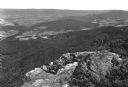
| Description: | Valley view from Skyline Drive. Four people on horseback look down upon the farmland of the valley from a rocky ledge. |

| Date: | |
|---|---|
| Description: | Visitors walk along a path underneath a natural land bridge. |

| Date: | 1864 |
|---|---|
| Description: | This battlefield map of the Battle of Totopotomoy Creek, also known as the Battle of Bethesda Church, shows the railroads, roads, vegetation and topography... |
If you didn't find the material you searched for, our Library Reference Staff can help.
Call our reference desk at 608-264-6535 or email us at: