 Filter: Categories of Wisconsin Historical Images
Filter: State of Virginia
Filter: Subject of military art and science
Filter: Subject of water
Filter: Categories of Wisconsin Historical Images
Filter: State of Virginia
Filter: Subject of military art and science
Filter: Subject of water
| Date: | 07 21 1921 |
|---|---|
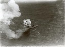
| Description: | One of the most important moments in the history of American aviation - the sinking of the captured German battleship "Ostfriesland" by American bombers of... |
| Date: | 06 1862 |
|---|---|
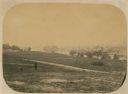
| Description: | The 7th Wisconsin Volunteer Infantry Regiment camp outside of Fredericksburg on the east side of the Rappahannock. Fredericksburg and a pontoon bridge lea... |
| Date: | |
|---|---|
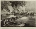
| Description: | Currier & Ives lithograph of the fall of Richmond, April 2, 1865. |
| Date: | |
|---|---|
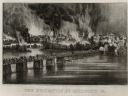
| Description: | "The Evacuation of Richmond Virginia. By the Government of the Southern Confederacy on the Night of April 2nd 1865." Before evacuating, the Confederates se... |
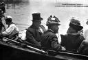
| Date: | |
|---|---|
| Description: | William Howard Taft (S9/15/1857 – 3/8/1930), the 27th President of the United States (3/4/1909 – 3/4/1913), wearing a top hat and sitting in a boat with a ... |
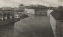
| Date: | |
|---|---|
| Description: | The old fortifications at Fort Monroe, built to defend Hampton Roads and the mouth of the James River. Jefferson Davis was imprisoned here from 1865 to 186... |
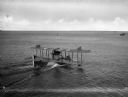
| Date: | |
|---|---|
| Description: | A rear view of a sea plane marked with the number 1700 landing in Hampton Roads Harbor. On the right, another plane can be seen in the water. |
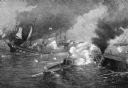
| Date: | |
|---|---|
| Description: | A painting of 'The Battle Between the Monitor and the Merrimac.' The work commemorates the Battle of Hampton Roads, fought on March 8–9, 1862, and depicts ... |
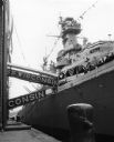
| Date: | 1957 |
|---|---|
| Description: | View of the U.S.S. Wisconsin docked during decommissioning ceremonies in preparation for its final cruise. A number of sailors can be seen on deck. |
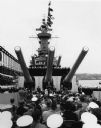
| Date: | 1957 |
|---|---|
| Description: | Ceremony beneath the guns on board the U.S.S. Wisconsin. A number of spectators and sailors are seated in the foreground, and uniformed sailors line... |
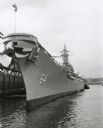
| Date: | 1957 |
|---|---|
| Description: | U.S.S. Wisconsin docked on the Hudson River at Norfolk, during decommissioning ceremonies. |
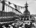
| Date: | 11 1957 |
|---|---|
| Description: | Uniformed sailors gathered on the deck of the U.S.S. Wisconsin during decommissioning ceremonies. |

| Date: | 1863 |
|---|---|
| Description: | This map shows roads, railroads, settlements, farms with owners' names, vegetation, streams, and fords in Culpeper County region during the Civil War. A ma... |

| Date: | 1862 |
|---|---|
| Description: | The first in a series of three maps of the Virginia Peninsula. This map details the area from Williamsburg south to Fortress Monroe at Hampton Roads and sh... |

| Date: | 1862 |
|---|---|
| Description: | The second in a series of three maps of the Virginia Peninsula. This map details the area from Williamsburg north to West Point. |

| Date: | 1862 |
|---|---|
| Description: | The third in a series of three maps of the Virginia Peninsula. This map details the area from Harrison's Landing west to Richmond and shows troop positions... |

| Date: | 1864 |
|---|---|
| Description: | This map of the battlefield on the North Anna River at Hanover Junction illustrates the Union positions in blue and Confederate positions in red. Roads, ra... |

| Date: | 1864 |
|---|---|
| Description: | This map of the area of the First Battle of Bull Run shows military positions and troop movements as well as the names of landowners, vegetation and land u... |

| Date: | 1864 |
|---|---|
| Description: | This map created during the Civil War indicates Confederate fortifications, houses, names of residents, towns, roads, railroads, relief by hachures, draina... |
If you didn't find the material you searched for, our Library Reference Staff can help.
Call our reference desk at 608-264-6535 or email us at:
