 Filter: Categories of Wisconsin Historical Images
Filter: State of Virginia
Filter: Subject of mountains
Filter: Subject of agriculture
Filter: Categories of Wisconsin Historical Images
Filter: State of Virginia
Filter: Subject of mountains
Filter: Subject of agriculture

| Date: | 1770 |
|---|---|
| Description: | The south west sheet of a four sheet map of Virginia, showing the counties, mountains, rivers, court houses, a few cities, and mills. A few Plantations ar... |

| Date: | 1671 |
|---|---|
| Description: | Map of Virginia depicting the discoveries detailed by John Smith in his exploration of the region. It shows Jamestown, Native American tribes and villages,... |

| Date: | 1755 |
|---|---|
| Description: | Map of Virginia and parts of Maryland, North Carolina, and New Jersey. It shows borders, boundary lines, some Native American land, counties, cities, towns... |

| Date: | 1762 |
|---|---|
| Description: | Map of Virginia and parts of Maryland. It shows borders, boundary lines, Native American tribes and land, towns, forts, roads, mountains, waterfalls, bays,... |
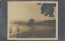
| Date: | 07 14 1909 |
|---|---|
| Description: | View looking down on fenced fields, with some harvested bundles of what may be hay. There are two reapers parked near the fence. In the distance are mounta... |
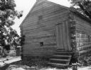
| Date: | 05 09 1938 |
|---|---|
| Description: | View towards the front and right side of the slave cabin built of chinked logs with a peaked roof. Steps lead up to the door, and a small window is on the ... |
If you didn't find the material you searched for, our Library Reference Staff can help.
Call our reference desk at 608-264-6535 or email us at: