 Filter: Categories of Wisconsin Historical Images
Filter: State of Virginia
Filter: Subject of mountains
Filter: Categories of Wisconsin Historical Images
Filter: State of Virginia
Filter: Subject of mountains

| Date: | 02 21 1874 |
|---|---|
| Description: | African American boatmen run a rapids in a small river boat. |
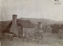
| Date: | 1900 |
|---|---|
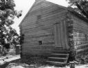
| Description: | Run-down building with a stone chimney in a rural landscape. The photograph is identified as "Steele's Tavern." Cyrus McCormick successfully demonstrated h... |
| Date: | |
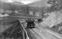
|---|---|
| Description: | Elevated view of two cars on a dirt road heading downhill. A town is in the valley below, and mountains are in the distance. |
| Date: | |
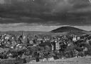
|---|---|
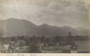
| Description: | Elevated view of a densely settled town in the Shenandoah valley. In the background are the foothills of the Appalachian mountains. Caption reads, "Bird's-... |

| Date: | |
|---|---|
| Description: | A hand-drawn map of Indian boundary lines in southwest Virginia. It also includes the Duck River and the Elk River. |

| Date: | |
|---|---|
| Description: | Elevated view of a road and river winding through a mountainous landscape, seen from Waterlick White Hotel. Caption reads: "View from Hotel, Waterlick whit... |

| Date: | |
|---|---|
| Description: | Elevated view of a colony of residences in a mountain setting. |

| Date: | 1862 |
|---|---|
| Description: | This map consists of four separate panels. The first illustrates the battlefield at Cedar Mountain on Aug. 9, 1862, where the 3rd Wisconsin Infantry fought... |

| Date: | 1770 |
|---|---|
| Description: | The south west sheet of a four sheet map of Virginia, showing the counties, mountains, rivers, court houses, a few cities, and mills. A few Plantations ar... |

| Date: | 1671 |
|---|---|
| Description: | Map of Virginia depicting the discoveries detailed by John Smith in his exploration of the region. It shows Jamestown, Native American tribes and villages,... |

| Date: | 1755 |
|---|---|
| Description: | Map of Virginia and parts of Maryland, North Carolina, and New Jersey. It shows borders, boundary lines, some Native American land, counties, cities, towns... |

| Date: | 1762 |
|---|---|
| Description: | Map of Virginia and parts of Maryland. It shows borders, boundary lines, Native American tribes and land, towns, forts, roads, mountains, waterfalls, bays,... |
| Date: | 07 14 1909 |
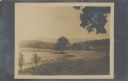
|---|---|
| Description: | View looking down on fenced fields, with some harvested bundles of what may be hay. There are two reapers parked near the fence. In the distance are mounta... |

| Date: | |
|---|---|
| Description: | Photograph from album with the caption: "Old Barn." The view is down a hill towards the barn which has a fenced enclosure. A horse-drawn buggy is near the ... |
| Date: | |
|---|---|
| Description: | Elevated view over roofs of farm buildings toward the Blue Ridge Mountains. Handwritten at bottom: "Blue Ridge Mts." |

| Date: | 01 1938 |
|---|---|
| Description: | Men are standing on scaffolding working on the roof near the top of the chimney. A tree is near the log building on the right, and mountains are in the dis... |

| Date: | 03 26 1938 |
|---|---|
| Description: | Three men are working on the top of the mill building. There is no roof, and the logs are not filled in or chinked. The road curves from the left in the ba... |
| Date: | 05 09 1938 |
|---|---|
| Description: | View towards the front and right side of the slave cabin built of chinked logs with a peaked roof. Steps lead up to the door, and a small window is on the ... |
If you didn't find the material you searched for, our Library Reference Staff can help.
Call our reference desk at 608-264-6535 or email us at: