 Filter: Categories of Wisconsin Historical Images
Filter: State of Virginia
Filter: Subject of rivers
Filter: Subject of dwellings
Filter: Categories of Wisconsin Historical Images
Filter: State of Virginia
Filter: Subject of rivers
Filter: Subject of dwellings

| Date: | 06 1862 |
|---|---|
| Description: | The 7th Wisconsin Volunteer Infantry Regiment camp outside of Fredericksburg on the east side of the Rappahannock. Fredericksburg and a pontoon bridge lea... |
| Date: | |
|---|---|
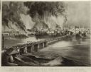
| Description: | Currier & Ives lithograph of the fall of Richmond, April 2, 1865. |
| Date: | |
|---|---|
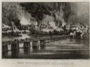
| Description: | "The Evacuation of Richmond Virginia. By the Government of the Southern Confederacy on the Night of April 2nd 1865." Before evacuating, the Confederates se... |

| Date: | |
|---|---|
| Description: | A hand-drawn map of Indian boundary lines in southwest Virginia. It also includes the Duck River and the Elk River. |

| Date: | |
|---|---|
| Description: | View down hill toward the York River with small homes on its banks. Long piers stretch into the river. |

| Date: | 1863 |
|---|---|
| Description: | This map shows roads, railroads, settlements, farms with owners' names, vegetation, streams, and fords in Culpeper County region during the Civil War. A ma... |

| Date: | 1950 |
|---|---|
| Description: | Front view of George Washington's Mount Vernon from the circular driveway. A line of people are waiting at the entrance. The cupola on the roof has a weath... |
If you didn't find the material you searched for, our Library Reference Staff can help.
Call our reference desk at 608-264-6535 or email us at: