 Filter: Categories of Wisconsin Historical Images
Filter: State of Virginia
Filter: Subject of rivers
Filter: Subject of men
Filter: Categories of Wisconsin Historical Images
Filter: State of Virginia
Filter: Subject of rivers
Filter: Subject of men

| Date: | 02 21 1874 |
|---|---|
| Description: | African American boatmen run a rapids in a small river boat. |
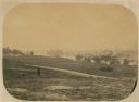
| Date: | 06 1862 |
|---|---|
| Description: | The 7th Wisconsin Volunteer Infantry Regiment camp outside of Fredericksburg on the east side of the Rappahannock. Fredericksburg and a pontoon bridge lea... |

| Date: | 1950 |
|---|---|
| Description: | Front view of George Washington's Mount Vernon from the circular driveway. A line of people are waiting at the entrance. The cupola on the roof has a weath... |

| Date: | 1671 |
|---|---|
| Description: | Map of Virginia depicting the discoveries detailed by John Smith in his exploration of the region. It shows Jamestown, Native American tribes and villages,... |

| Date: | 1755 |
|---|---|
| Description: | Map of Virginia and parts of Maryland, North Carolina, and New Jersey. It shows borders, boundary lines, some Native American land, counties, cities, towns... |
If you didn't find the material you searched for, our Library Reference Staff can help.
Call our reference desk at 608-264-6535 or email us at: