 Filter: Categories of Wisconsin Historical Images
Filter: State of Virginia
Filter: Subject of roads
Filter: Subject of dwellings
Filter: Categories of Wisconsin Historical Images
Filter: State of Virginia
Filter: Subject of roads
Filter: Subject of dwellings
| Date: | |
|---|---|
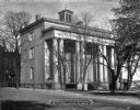
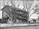
| Description: | View across street toward the Jefferson Davis mansion. Caption reads: "Jefferson Davis Mansion, now Confederate Museum." |
| Date: | 1864 |
|---|---|
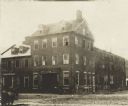
| Description: | Marshall House, in which Col. E.E. Ellsworth was shot on May 24, 1861. |
| Date: | 1864 |
|---|---|
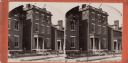
| Description: | A stereograph of exterior of General Lee's residence. |
| Date: | 1871 |
|---|---|
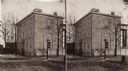
| Description: | Stereograph of exterior of a building used as the Confederate government's Executive Mansion. This was where Jefferson Davis and his family stayed during t... |

| Date: | |
|---|---|
| Description: | Exterior of Strasburg Hospital. The four-story structure on the right was attached to the large house on the left around 1902. Caption reads: "Strasburg, V... |
| Date: | 1878 |
|---|---|
| Description: | A view of the Native American male dormitory, called "Wigwam." The structure has three floors, each with a balcony. A smaller building is next to it on the... |

| Date: | |
|---|---|
| Description: | Elevated view of a colony of residences in a mountain setting. |

| Date: | |
|---|---|
| Description: | Elevated view of the Blue Ridge Terrace, a large hotel on a mountain overlooking the valley. Cars are parked near the road, and three men are gathered on t... |

| Date: | |
|---|---|
| Description: | View of an intersection of two dirt roads, East Market Street and Lafayette Street. A man, horseback, can be seen on the left, while two people walk past ... |
| Date: | |
|---|---|
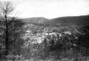
| Description: | Elevated view of town as seen from a hilly landscape. Published by The City Book Store. |

| Date: | 1864 |
|---|---|
| Description: | This map of the area of the First Battle of Bull Run shows military positions and troop movements as well as the names of landowners, vegetation and land u... |

| Date: | 1864 |
|---|---|
| Description: | This map created during the Civil War indicates Confederate fortifications, houses, names of residents, towns, roads, railroads, relief by hachures, draina... |

| Date: | 1865 |
|---|---|
| Description: | This detailed map of the area between Richmond and Petersburg shows fortifications, roads, railroads, towns, street patterns of Petersburg and Richmond, dr... |

| Date: | 1865 |
|---|---|
| Description: | The map of the battlefield shows entrenchments, villages, roads, the "South Side Rail Road" drainage, vegetation, relief by hachures, houses, and names of ... |

| Date: | 1938 |
|---|---|
| Description: | View toward a road with two large buildings, and a small building on the opposite side. In the foreground on the right is a monument. |

| Date: | |
|---|---|
| Description: | View down road and across fields toward the Walnut Grove farm. The manor house is in the background on the left, a large barn with a silo is in the center.... |
If you didn't find the material you searched for, our Library Reference Staff can help.
Call our reference desk at 608-264-6535 or email us at: