 Filter: Categories of Wisconsin Historical Images
Filter: State of Virginia
Filter: Subject of transportation
Filter: Subject of mountains
Filter: Categories of Wisconsin Historical Images
Filter: State of Virginia
Filter: Subject of transportation
Filter: Subject of mountains

| Date: | 02 21 1874 |
|---|---|
| Description: | African American boatmen run a rapids in a small river boat. |
| Date: | |
|---|---|
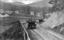
| Description: | Elevated view of two cars on a dirt road heading downhill. A town is in the valley below, and mountains are in the distance. |

| Date: | |
|---|---|
| Description: | Elevated view of a road and river winding through a mountainous landscape, seen from Waterlick White Hotel. Caption reads: "View from Hotel, Waterlick whit... |

| Date: | |
|---|---|
| Description: | Elevated view of a colony of residences in a mountain setting. |

| Date: | 1755 |
|---|---|
| Description: | Map of Virginia and parts of Maryland, North Carolina, and New Jersey. It shows borders, boundary lines, some Native American land, counties, cities, towns... |

| Date: | 1762 |
|---|---|
| Description: | Map of Virginia and parts of Maryland. It shows borders, boundary lines, Native American tribes and land, towns, forts, roads, mountains, waterfalls, bays,... |

| Date: | |
|---|---|
| Description: | Photograph from album with the caption: "Old Barn." The view is down a hill towards the barn which has a fenced enclosure. A horse-drawn buggy is near the ... |

| Date: | 03 26 1938 |
|---|---|
| Description: | Three men are working on the top of the mill building. There is no roof, and the logs are not filled in or chinked. The road curves from the left in the ba... |
If you didn't find the material you searched for, our Library Reference Staff can help.
Call our reference desk at 608-264-6535 or email us at: