 Filter: Categories of Wisconsin Historical Images
Filter: State of Virginia
Filter: Subject of warehouses
Filter: Categories of Wisconsin Historical Images
Filter: State of Virginia
Filter: Subject of warehouses
| Date: | |
|---|---|
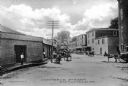
| Description: | View down Commerce Street featuring several wagons and a warehouse. Published by Parish & Simpson. |

| Date: | 1755 |
|---|---|
| Description: | Map of Virginia and parts of Maryland, North Carolina, and New Jersey. It shows borders, boundary lines, some Native American land, counties, cities, towns... |
If you didn't find the material you searched for, our Library Reference Staff can help.
Call our reference desk at 608-264-6535 or email us at: