 Filter: Categories of Wisconsin Historical Images
Filter: State of Virginia
Filter: Subject of water
Filter: Categories of Wisconsin Historical Images
Filter: State of Virginia
Filter: Subject of water

| Date: | 1744 |
|---|---|
| Description: | A map of a plan of 16,500 acres of land. |
| Date: | 1922 |
|---|---|
| Description: | Harold F. McCormick (with cup) and his children, left to right: Muriel, Harold, Jr. and Mathilde at the Walnut Grove farm in Rockbridge County. |

| Date: | 02 21 1874 |
|---|---|
| Description: | African American boatmen run a rapids in a small river boat. |
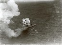
| Date: | 07 21 1921 |
|---|---|
| Description: | One of the most important moments in the history of American aviation - the sinking of the captured German battleship "Ostfriesland" by American bombers of... |
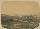
| Date: | 06 1862 |
|---|---|
| Description: | The 7th Wisconsin Volunteer Infantry Regiment camp outside of Fredericksburg on the east side of the Rappahannock. Fredericksburg and a pontoon bridge lea... |
| Date: | |
|---|---|
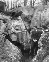
| Description: | A man kneels by large spring surrounded by split-rail fencing. |
| Date: | |
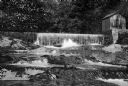
|---|---|
| Description: | View looking up toward a water works, a dam, and natural falls on the Jackson River with woods in the background. |
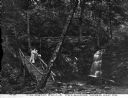
| Date: | |
|---|---|
| Description: | A couple walking down the rustic stairway at Caldeno Falls. Caption reads: "Caldeno Falls, Delaware Water Gap, PA." |

| Date: | |
|---|---|
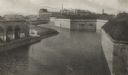
| Description: | An aerial view of the port and a section of the city showing a large boat, a railway depot, a park plaza and a grid of city streets with large buildings. |
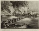
| Date: | |
|---|---|
| Description: | Currier & Ives lithograph of the fall of Richmond, April 2, 1865. |
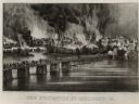
| Date: | |
|---|---|
| Description: | "The Evacuation of Richmond Virginia. By the Government of the Southern Confederacy on the Night of April 2nd 1865." Before evacuating, the Confederates se... |
| Date: | |
|---|---|
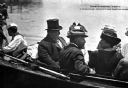
| Description: | William Howard Taft (S9/15/1857 – 3/8/1930), the 27th President of the United States (3/4/1909 – 3/4/1913), wearing a top hat and sitting in a boat with a ... |
| Date: | |
|---|---|
| Description: | The old fortifications at Fort Monroe, built to defend Hampton Roads and the mouth of the James River. Jefferson Davis was imprisoned here from 1865 to 186... |
| Date: | |
|---|---|
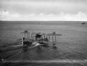
| Description: | A rear view of a sea plane marked with the number 1700 landing in Hampton Roads Harbor. On the right, another plane can be seen in the water. |
| Date: | |
|---|---|
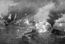
| Description: | A painting of 'The Battle Between the Monitor and the Merrimac.' The work commemorates the Battle of Hampton Roads, fought on March 8–9, 1862, and depicts ... |
| Date: | |
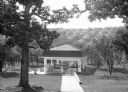
|---|---|
| Description: | View looking down into a covered shelter, built in the early 1900's, for Massanetta Springs. A group of people are sitting in the shelter which is in a cou... |

| Date: | |
|---|---|
| Description: | A hand-drawn map of Indian boundary lines in southwest Virginia. It also includes the Duck River and the Elk River. |

| Date: | |
|---|---|
| Description: | Elevated view of a road and river winding through a mountainous landscape, seen from Waterlick White Hotel. Caption reads: "View from Hotel, Waterlick whit... |
If you didn't find the material you searched for, our Library Reference Staff can help.
Call our reference desk at 608-264-6535 or email us at:

