 Filter: Categories of Wisconsin Historical Images
Filter: State of Wisconsin
Filter: Subject of blueprints
Filter: Categories of Wisconsin Historical Images
Filter: State of Wisconsin
Filter: Subject of blueprints
| Date: | 12 11 1936 |
|---|---|
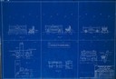
| Description: | Blueprint design for seats for Copper Falls State Park. |
| Date: | 05 21 1936 |
|---|---|
| Description: | Blueprint design for a trail side shelter at Copper Falls State Park. |
| Date: | 01 09 1940 |
|---|---|
| Description: | Blueprint design for a suspension footbridge for Copper Falls State Park. |
| Date: | |
|---|---|
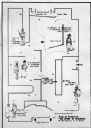
| Description: | Blueprint design of the master plan for Copper Falls State Park. |
| Date: | |
|---|---|
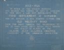
| Description: | Blueprint of the Military Road marker design, which honors the pioneers who established the first settlement in Superior. |
| Date: | 1934 |
|---|---|
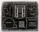
| Description: | A blueprint of a survey done of the Michael Brisbois House. |

| Date: | 1900 |
|---|---|
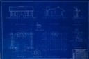
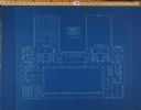
| Description: | Floor plan for the second floor library and offices of the State Historical Society building designed by architects Ferry & Clas and constructed in 1900. F... |
| Date: | 1900 |
|---|---|
| Description: | Floor plan for the third floor of the State Historical Society building designed by architects Ferry & Clas and constructed in 1900. |

| Date: | 1900 |
|---|---|
| Description: | Sheet #26 of the plans for the State Historical Society building prepared by architects Ferry & Clas, showing longitudinal sections of corridor 142 and Roo... |

| Date: | 1900 |
|---|---|
| Description: | Sheet # 25 of the plans submitted by architects Ferry & Clas for the construction of the State Historical Society building, showing longitudinal sections o... |
| Date: | 1900 |
|---|---|
| Description: | Sheet #27 of the plans submitted by architects Ferry & Clas for the State Historical Society building showing a section of all four stories of the building... |

| Date: | 1900 |
|---|---|
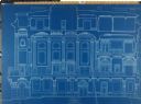
| Description: | Sheets 21: Exterior section through the main loggia (Room 226) and portion of the east elevation, 1 1/2 bays of the loggia. |

| Date: | 1907 |
|---|---|
| Description: | Topographic map of the Wisconsin River done under direction of Daniel Meade for construction of the Kilbourn dam by the Southern Wisconsin Power Company. I... |

| Date: | 1926 |
|---|---|
| Description: | This hand-colored blueprint map shows landowners in part of T15N, R5E in Juneau County. North is oriented to the right. |

| Date: | 1927 |
|---|---|
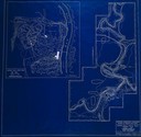
| Description: | Blueprint-style map of Frost Woods on the shore of Lake Monona. The map indicates the locations of Indian mounds, an Indian camp, and various plants. There... |
| Date: | 08 1948 |
|---|---|
| Description: | Floor plan of the Wisconsin Historical Society's "Story of Wisconsin" exhibit at the Wisconsin Centennial Exposition. |

| Date: | 06 08 1960 |
|---|---|
| Description: | Blueprint plat of Sunset Hills sub-division. |
| Date: | |
|---|---|
| Description: | Building blueprints for ground plan for the North Dakota Mill and Grain Company, Courtenay, North Dakota. |
| Date: | |
|---|---|
| Description: | Cross-section building blueprints for the North Dakota Mill and Grain Company, Courtenay, North Dakota. |

| Date: | 1933 |
|---|---|
| Description: | Blue print and blue line print maps that show local streets, Nakoma Country Club, part of Lake Forest, and part of Lake Wingra. A legend is included that s... |
If you didn't find the material you searched for, our Library Reference Staff can help.
Call our reference desk at 608-264-6535 or email us at: