 Filter: Categories of Wisconsin Historical Images
Filter: State of Wyoming
Filter: Subject of landforms
Filter: Categories of Wisconsin Historical Images
Filter: State of Wyoming
Filter: Subject of landforms
| Date: | |
|---|---|
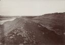
| Description: | The Fort Smith Bluffs at the Big Horn Ditch on the Crow Reservation in northeast Wyoming. |
| Date: | |
|---|---|
| Description: | The Fort Smith Bluffs at the Big Horn Ditch on the Crow Reservation in northeast Wyoming. |
| Date: | |
|---|---|
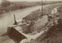
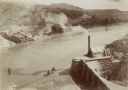
| Description: | The head gate of the Big Horn Ditch on the Crow Reservation in northeast Wyoming. |
| Date: | |
|---|---|
| Description: | The head gate of the Big Horn Ditch on the Crow Reservation in northeast Wyoming. |
| Date: | |
|---|---|
| Description: | The head gate of the Big Horn Ditch on the Crow Reservation in northeast Wyoming. |
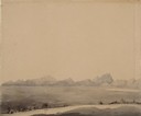
| Date: | 07 10 1849 |
|---|---|
| Description: | The clay hills that were formed by the Sweetwater River in Wyoming; sketched by Wilkins on his 151-day journey from Missouri to California on the Overland ... |
| Date: | 07 10 1849 |
|---|---|
| Description: | Independence Rock (the perceived midway point on the Oregon Trail),Wyoming, with two wagons unhitched at the base of the rock; sketched by Wilkins on his 1... |
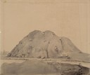
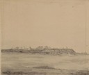
| Date: | 07 24 1849 |
|---|---|
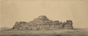
| Description: | Cathedral Rock in Wyoming; sketched by Wilkins on his 151-day journey from Missouri to California on the Overland Trail (also known as the Oregon Trail). |
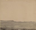
| Date: | 07 24 1849 |
|---|---|
| Description: | The Clay Bluffs in Wyoming; sketched by Wilkins on his 151-day journey from Missouri to California on the Overland Trail (also known as the Oregon Trail). |
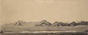
| Date: | 07 10 1849 |
|---|---|
| Description: | Sweetwater River and the Red Buttes in Wyoming; sketched by Wilkins on his 151-day journey from Missouri to California on the Overland Trail (also known as... |
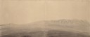
| Date: | 07 16 1849 |
|---|---|
| Description: | South Pass in Wyoming; sketched by Wilkins on his 151-day journey from Missouri to California on the Overland Trail (also known as the Oregon Trail). Wilki... |
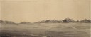
| Date: | 07 17 1849 |
|---|---|
| Description: | Pacific Springs, Wyoming; sketched by Wilkins on his 151-day journey from Missouri to California on the Overland Trail (also known as the Oregon Trail). Wi... |
| Date: | 07 24 1849 |
|---|---|
| Description: | Cathedral Rock in Wyoming with three wagons; sketched by Wilkins on his 151-day journey from Missouri to California on the Overland Trail (also known as th... |

| Date: | 09 1910 |
|---|---|
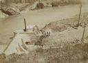
| Description: | Men working at the Leighton-Wyoming mining camp stand near a large building, possibly a sawmill, related to the mining operation. A steep hill rises in the... |

| Date: | 09 1910 |
|---|---|
| Description: | Three man stand in a small clearing on a steep rocky hill amid fallen trees. The small waterfall behind the men was the water power for the Leighton-Wyomin... |

| Date: | |
|---|---|
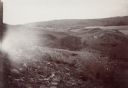
| Description: | Elevated view of the painted Badlands reaching out to the horizon. |

| Date: | |
|---|---|
| Description: | View of the Salt Creek Oil Field. In the 1920's, one-fifth of all petroleum produced in the United States came from one oil field. |
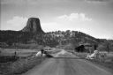
| Date: | |
|---|---|
| Description: | View of a highway leading towards Devils Tower. A sign before a cabin on the right reads, "U.S. Department of Interior, Devils Tower, National Monument, Na... |
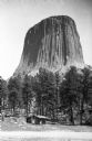
| Date: | |
|---|---|
| Description: | View of the distant Devils Tower, a large striated rock formation. A couple stands in the foreground near a small log cabin among trees. |
If you didn't find the material you searched for, our Library Reference Staff can help.
Call our reference desk at 608-264-6535 or email us at: