Filter: Type of Drawing
Filter: Subject of human settlements
Filter: Subject of intellectual life
Filter: Type of Drawing
Filter: Subject of human settlements
Filter: Subject of intellectual life

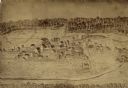
| Date: | 1907 |
|---|---|
| Description: | Bird's-eye view of the University of Wisconsin-Madison campus looking northwest. Building at top of hill, to left of center is Bascom Hill (Main Hall) and... |

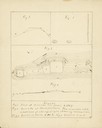
| Date: | 1780 |
|---|---|
| Description: | Hand-drawn plan for the layout of the town of Clarksville, bordering Mayfield Creek and Liberty Creek. Fort Jefferson is shown between the townsite and the... |

| Date: | 08 24 1876 |
|---|---|
| Description: | Hand-drawn plan of the battleground of Huycks. |

| Date: | 03 26 1876 |
|---|---|
| Description: | Hand-drawn map showing the place of Hook's defeat in York County in South Carolina. |
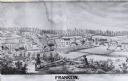
| Date: | 1857 |
|---|---|
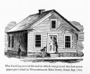
| Description: | Green Bay Intelligencer Newspaper Office. This was the first newspaper published in Wisconsin. The building was on Main Street. This drawing appeared in an... |

| Date: | 08 10 1862 |
|---|---|
| Description: | A hand-drawn map of the Battle of Wilson's Creek, Springfield, Missouri. Other notes and locations include: "Lyon was killed instantly while heading his tr... |
| Date: | 1899 |
|---|---|
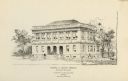
| Description: | The Elisha D. Smith Library built by Van Ryn and De Gelleke. |
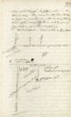
| Date: | |
|---|---|
| Description: | Drawn map of Landsford, South Carolina, from Thomas Sumter Papers. |

| Date: | 1855 |
|---|---|
| Description: | Fox-Wisconsin portage and canal map, when the canal was not yet built. From a map in the office of the city clerk at Portage. "The old trail, the location ... |
| Date: | |
|---|---|
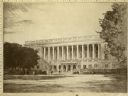
| Description: | Drawing of an exterior view of the State Historical Society of Wisconsin headquarters building, now the Wisconsin Historical Society. |

| Date: | 1837 |
|---|---|
| Description: | Copy of N.F. Hyer's original map of Aztalan as published in the Milwaukee Advertiser, February 25, 1837. |
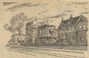
| Date: | 10 30 1946 |
|---|---|
| Description: | At North Jackson and East Mason Streets, with the Sherman home (extreme left) and the Newton home (center). Four buildings are along the road. |

| Date: | 04 12 1912 |
|---|---|
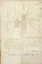
| Description: | Diagram of a bird effigy mound found in Frost's Woods, Blooming Grove Township. |

| Date: | 06 08 1960 |
|---|---|
| Description: | Blueprint plat of Sunset Hills sub-division. |

| Date: | 04 15 1915 |
|---|---|
| Description: | A sketch of Little Lake Butte des Morts and the surrounding area, including Neenah and Menasha. |

| Date: | 1608 |
|---|---|
| Description: | Illustraiton, with alphabetical key in French, of the Habitation of Quebec, a conglomeration of connected buildings on the banks of the St. Lawrence River ... |
If you didn't find the material you searched for, our Library Reference Staff can help.
Call our reference desk at 608-264-6535 or email us at: