 Filter: Type of Map or Atlas
Filter: Creator Name of Unknown
Filter: Type of Map or Atlas
Filter: Creator Name of Unknown

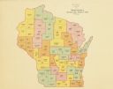
| Date: | 1910 |
|---|---|
| Description: | This early 20th-century map of Wisconsin counties indicates indicate the Wisconsin counties in which there are county historical societies auxiliary to the... |

| Date: | 1935 |
|---|---|
| Description: | This map shows in different colors virgin timberland, second growth timber, pasture belt, crop-pasture belt, intensive crop-pasture belt, intensive pasture... |

| Date: | 1938 |
|---|---|
| Description: | This map shows "regional designation problem areas" and "nature of problem or solution." The left margin has a key showing the problem areas. The right mar... |

| Date: | 1900 |
|---|---|
| Description: | A map of Wisconsin, eastern Minnesota and Iowa, northern Iowa, and Michigan’s Upper Peninsula, showing railway lines, with those marked with heavy red line... |
| Date: | 1900 |
|---|---|
| Description: | A map of Wisconsin showing the seventeen judicial circuits of the state. The map also shows the counties of Wisconsin and the total population of each of t... |
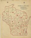
| Date: | 1922 |
|---|---|
| Description: | A map of Wisconsin showing the state’s Assembly Districts. It also provides the population total of each county. |
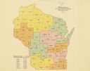
| Date: | 1922 |
|---|---|
| Description: | A map of Wisconsin showing the state’s congressional districts, it also provides the population total for the state, each district and each county. |
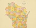
| Date: | 1922 |
|---|---|
| Description: | A map of Wisconsin showing the state’s Senate districts, it also provides the population total for each county. |
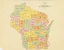
| Date: | 1922 |
|---|---|
| Description: | A map of Wisconsin showing the state’s judicial districts, it also provides the population total for each county. |

| Date: | 1912 |
|---|---|
| Description: | A map shows the Presbyterian churches, presbyteries, and districts in Wisconsin, as well as the counties, the locations cities and towns in the state. Indi... |

| Date: | 1856 |
|---|---|
| Description: | A map showing rail lines in Wisconsin and the railroad land grants of the Superior & St. Croix Railroad in the present-day northwestern Wisconsin counties ... |

| Date: | 1890 |
|---|---|
| Description: | A map of Wisconsin, eastern Wisconsin and Iowa, northern Illinois, and the Upper Peninsula of Michigan. The counties, cities and villages, and rail lines i... |

| Date: | 1854 |
|---|---|
| Description: | This map is ink and watercolor on tracing cloth and shows lot and block numbers, streets, a park, and depots. Some lots are colored red or blue and some in... |

| Date: | 1892 |
|---|---|
| Description: | This map oriented with north to the upper left shows railroads, creeks, post offices, smaller lakes, Lake Mendota, Lake Monona, Lake Wingra, Lake Waubesa, ... |

| Date: | |
|---|---|
| Description: | Pen and ink tracing showing the positions of Union and Confederate soldiers, troop camps, location of graves, roads, drainage, vegetation, houses, and fenc... |

| Date: | 1860 |
|---|---|
| Description: | A hand-drawn, ink on cloth map of southeastern Wisconsin that show roads and railroads that connect Chicago to Milwaukee and other towns in the southeaster... |

| Date: | 1864 |
|---|---|
| Description: | A geological map of Wisconsin that shows the locations of different rock deposits such as limestone, sandstone, shale, plutonic and the Penokee Iron Range.... |

| Date: | 1868 |
|---|---|
| Description: | Wisconsin and parts of Michigan, Minnesota, Illinois and Iowa. It shows cities and towns, drainage, administrative boundaries and the railroad network with... |

| Date: | 1875 |
|---|---|
| Description: | A hand-drawn and colored map of Wisconsin showing the railroad routs and railroad land grants La Cross and Milwaukee Railroad, St. Croix and Tomah Railroad... |

| Date: | 1882 |
|---|---|
| Description: | A geological map of northern Wisconsin showing the locations of different soil types in the state such as sandy soil, sandy loam, prairie loam, clayey loam... |
If you didn't find the material you searched for, our Library Reference Staff can help.
Call our reference desk at 608-264-6535 or email us at: