Filter: Type of Map or Atlas
Filter: Creator Name of Unknown
Filter: Type of Map or Atlas
Filter: Creator Name of Unknown

| Date: | 1829 |
|---|---|
| Description: | Photoprint of Crawford County lead district map. |

| Date: | 1874 |
|---|---|
| Description: | Map of New Diggings — inset map in bottom right corner of "Benton & New Diggings" map, on page 11 of "Atlas of Lafayette County Wisconsin," a collect... |

| Date: | 1761 |
|---|---|
| Description: | A plan of the Straits of St. Mary and Michilimakinac, to shew the situation and importance of the two westernmost settlements of Canada for the fur trade. ... |

| Date: | 1872 |
|---|---|
| Description: | Map of the Chippewa River, from the head of navigation at the city of Chippewa Falls, covering a distance of 16 miles above : showing the established impro... |

| Date: | 1839 |
|---|---|
| Description: | Map of a canal route to avoid the principal rapids of the Neenah or Fox River between Lake Winnebago and Green Bay. |

| Date: | 1872 |
|---|---|
| Description: | Map entitled Office Wallbridge Bro. U. Sargent showing upper Minnesota and Wisconsin, as well as Lake Superior. |

| Date: | |
|---|---|
| Description: | Hand-drawn, folded extension of map, rendered on notebook paper. |

| Date: | 1825 |
|---|---|
| Description: | Portion of a map showing a survey of Lake Superior including the River St. Louis. |
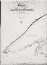
| Date: | 1825 |
|---|---|
| Description: | Survey of Lake Superior including Wisconsin and Minnesota. |

| Date: | 1863 |
|---|---|
| Description: | Map of the west end of Lake Superior, including Superior, St. Louis, and Allouez Bays. |
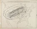
| Date: | 1871 |
|---|---|
| Description: | Weather map depicting the great cyclonic storm that prevailed the day of the Peshtigo and Chicago fires. |

| Date: | 1873 |
|---|---|
| Description: | Portion of Winnebago County map showing Lake Winneconne and the Wolf River. |

| Date: | 1784 |
|---|---|
| Description: | Map of The United States of America according to the Treaty of Peace of 1784. |
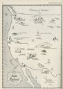
| Date: | 06 1930 |
|---|---|
| Description: | A map of the western states showing "public playlands," mostly national parks. |
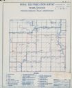
| Date: | |
|---|---|
| Description: | Rural electrification survey map of Marquette county in Westfield township. |
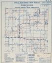
| Date: | |
|---|---|
| Description: | Rural electrification survey map of Waushara county in Springwater township. |
If you didn't find the material you searched for, our Library Reference Staff can help.
Call our reference desk at 608-264-6535 or email us at: