 Filter: Type of Map or Atlas
Filter: Subject of transportation
Filter: Type of Map or Atlas
Filter: Subject of transportation

| Date: | 1893 |
|---|---|
| Description: | Bird's-eye map of Jefferson, looking north. Crayfish River at left and center, Rock River from upper center to bottom center, joins at left of center; thir... |

| Date: | 12 21 1882 |
|---|---|
| Description: | Bird's-eye map of Kaukauna, from the Appleton Post Annual Review. |

| Date: | 1878 |
|---|---|
| Description: | Bird's-eye map of Kewaskum. Includes a list of hotels, churches, post office, railroad depot, etc. |
| Date: | 1893 |
|---|---|
| Description: | Bird's-eye map of Kewaunee, with inset of The Kewaunee and Frankfort Car Ferry Line. |

| Date: | 1870 |
|---|---|
| Description: | Bird's-eye map of Kilbourn City, now known as Wisconsin Dells. Kilbourn City was platted in the 1850s and received a boost when the La Crosse and Milwaukee... |

| Date: | 1879 |
|---|---|
| Description: | Bird's-eye map of Lake Mills. |

| Date: | 1874 |
|---|---|
| Description: | Bird's-eye map of Lodi, with inset of Public School. Includes index of churches and points of interest. |

| Date: | 1870 |
|---|---|
| Description: | Bird's-eye map of Madison. The Lakeside House resort is in the foreground, which burned in 1877, in what is now Olin Park. |

| Date: | 1883 |
|---|---|
| Description: | Bird's-eye map of Manitowoc. |

| Date: | 1883 |
|---|---|
| Description: | Bird's-eye map of Marshfield, with one vignette. |

| Date: | 1875 |
|---|---|
| Description: | Bird's-eye map of Mazomanie. |

| Date: | 1881 |
|---|---|
| Description: | Bird's-eye map of Milton Junction. |

| Date: | 1898 |
|---|---|
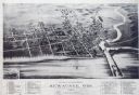
| Description: | Bird's-eye map, looking west from shoreline on Lake Michigan of Milwaukee to Golden Lake in Waukesha County, with Kenosha and Fox Point at bottom corners, ... |

| Date: | 1927 |
|---|---|
| Description: | Color map, hand-drawn with comic figures engaged in various activities throughout map. Bordered by the river on the left and Lake Michigan on the right, in... |
| Date: | 1872 |
|---|---|
| Description: | Bird's-eye map of Mineral Point, looking southeast. |
If you didn't find the material you searched for, our Library Reference Staff can help.
Call our reference desk at 608-264-6535 or email us at:


