 Filter: Creator Name of Bonne, Rigobert
Filter: Subject of niagara falls (n.y. and ont.)
Filter: Creator Name of Bonne, Rigobert
Filter: Subject of niagara falls (n.y. and ont.)
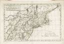
| Date: | 1783 |
|---|---|
| Description: | Map of the north east coast of the United States, north of Virginia and east of Lake Erie. It shows the states, forts, cities, towns, mountains, Niagara Fa... |
If you didn't find the material you searched for, our Library Reference Staff can help.
Call our reference desk at 608-264-6535 or email us at: