 Filter: Creator Name of Lapham, Increase Allen

| Date: | 1864 |
|---|---|
| Description: | This map is pen and watercolor on paper and shows a profile and the geological formation of Blue Mound. Also shown is the location of Arnold's Hotel and Br... |

| Date: | 1864 |
|---|---|
| Description: | This map shows locations of quarries, sink holes, creeks, springs, rivers, houses, forts, and roads. Annotations in pencil read: "Is the top of the mound l... |

| Date: | 1864 |
|---|---|
| Description: | This map shows locations of quarries, sink holes, creeks, springs, rivers, houses, forts, and roads. The upper right corner and right margin includes anno... |

| Date: | 1864 |
|---|---|
| Description: | Map showing locations of quarries, sink holes, creeks, springs, rivers, houses, forts, and roads. The map appears to have been drawn on to of a plat map of... |

| Date: | 1864 |
|---|---|
| Description: | This map shows locations of quarries, sink holes, creeks, springs, rivers, houses, forts, and roads. |

| Date: | 1870 |
|---|---|
| Description: | This map is mostly pencil on paper map but includes latitude and longitude grid in ink. The map covers the Mississippi River from Lake Itasca to the Wiscon... |

| Date: | 1840 |
|---|---|
| Description: | This map is pencil on paper and shows rivers, granite locations, and selected landmarks. Relief is shown by hachures. |

| Date: | 1867 |
|---|---|
| Description: | This pen and ink map shows counties outlined in red, cities over 3,000 inhabitants, and county seats. The bottom margin includes a handwritten description ... |

| Date: | |
|---|---|
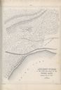
| Description: | Three separate maps: Ancient Works Near Manitowoc (surveyed 1850), Ancient Works on the North Side of Lake Wingra (surveyed 1850), and Mounds at Madison (s... |

| Date: | 1850 |
|---|---|
| Description: | Diagrams of four effigy mounds surveyed by Increase A. Lapham and W.H. Canfield in 1850. No. 1 is an unidentified animal shape, No. 2 consists of two linea... |
| Date: | 1850 |
|---|---|
| Description: | A drawing of ancient works at the southeast angle of the Third Lake. |
| Date: | 09 1870 |
|---|---|
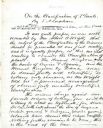
| Description: | The first page of a handwritten lecture titled "On the Classification of Plants" by Increase Lapham. |
| Date: | 02 1876 |
|---|---|
| Description: | The cover page of a speech handwritten by Increase Lapham titled: "On the Law of Embryonic Development Showing that it is the Same in Plants as in Animals.... |
| Date: | 1876 |
|---|---|
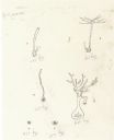
| Description: | Four drawings showing embryonic development in plants. |
| Date: | 1876 |
|---|---|
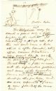
| Description: | Page 11 of a speech written by Increase Lapham on embryonic development in plants. There are drawings at the top of the page. |
| Date: | 1876 |
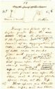
|---|---|
| Description: | Page 13 of a speech written by Increase Lapham on embryonic development in plants. There are drawings at the top of the page. |

| Date: | 1845 |
|---|---|
| Description: | Map of Wisconsin, including lower western border with Iowa, southern border along Illinois, eastern shoreline of Lake Michigan, and northern area along Wis... |
If you didn't find the material you searched for, our Library Reference Staff can help.
Call our reference desk at 608-264-6535 or email us at: