 Filter: Creator Name of Lapham, Increase Allen
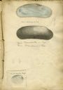
| Date: | 1828 |
|---|---|
| Description: | Increase Lapham's drawing of a Union mondonta (or Unio soleniformis) shell. There are also two views of another shell drawn below and a drawi... |

| Date: | 1828 |
|---|---|
| Description: | Increase Lapham drawings of Poa pratensis, Festuca duriuscula, Lolium prenne, Alopecurus pratensis, Anthoxanthum odoratum |
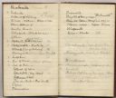
| Date: | 1835 |
|---|---|
| Description: | Page from Increase Lapham's 1935 botanical diary in which he listed plants he observed in flower stage. |
| Date: | 1838 |
|---|---|
| Description: | Page from Increase Lapham's 1838 botanical diary in which he listed plants he observed in flower stage. |
| Date: | 1870 |
|---|---|
| Description: | Page from a diary kept by Increase Lapham in California between April 11 and May 19, 1870. The page shows a portion of a list of minerals of California. |
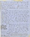
| Date: | 06 28 1850 |
|---|---|
| Description: | Letter from Increase Lapham to his wife, Ann Maria Alcott, in Milwaukee. Lapham was at Aztalan and wrote to Anna regarding the geology of the region. He in... |
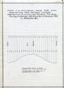
| Date: | 12 1860 |
|---|---|
| Description: | Graph showing the profile of a semi-diurnal spring tidal curve deduced from 5452 half hourly ordinates obtained from the records of self registering tide g... |

| Date: | 1850 |
|---|---|
| Description: | Map showing Indian mounds and graves as well as ground cover types at Township 8, Range 22. There is an inset diagram of an effigy mound labeled "The Cross... |
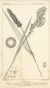
| Date: | |
|---|---|
| Description: | Increase Lapham's drawing of Setaris Italica or foxtail millet and Panicum miliaceum or proso millet. There are also inset drawings of a spik... |

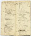
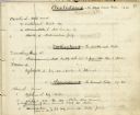
| Date: | 1849 |
|---|---|
| Description: | Handwritten list of plants in the Ranunculaceae or crowfoot family. |
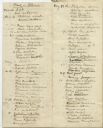
| Date: | 1845 |
|---|---|
| Description: | Page from Increase Lapham's 1845 list of plants of Wisconsin including Oxalidaceae, Zanthoxylaceae, and Anacardiaceae and notations of where and when indiv... |

| Date: | |
|---|---|
| Description: | Map showing Indian mounds in Milwaukee's Second Ward from a sketch made by Increase Lapham in 1836. Streets shown on the map include 6th Street, 5th Street... |

| Date: | 1840 |
|---|---|
| Description: | Map shows three Wisconsin territories, Jefferson, Waukesha, and Milwaukee. Map is ink, pencil, and watercolor on paper. Relief shown by hachures. |
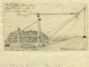
| Date: | 1827 |
|---|---|
| Description: | Increase Lapham's drawing of a rig designed by Mr. Orange Dibble for removing rocks and other large debris from deep canal cuts. |

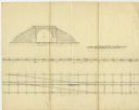
| Date: | 1828 |
|---|---|
| Description: | Drawing by Increase Lapham showing the geological profile of the land between Utica and Knob Creek, Kentucky at a scale of 1/2 inch to a mile. |
| Date: | 02 15 1830 |
|---|---|
| Description: | Increase Lapham's drawing of a railroad tunnel and railroad tracks. |

| Date: | 12 22 1830 |
|---|---|
| Description: | Increase Lapham's drawing of the geological profile between the Sandusky plains and Portsmouth, Ohio. |

| Date: | 1833 |
|---|---|
| Description: | Increase Lapham's plan for the canal terminus on Portsmouth Point at the confluence of the Scioto and Ohio Rivers. |

| Date: | 1844 |
|---|---|
| Description: | Increase Lapham's handwritten title page for A Geographical and Topographical Description of Wisconsin |

| Date: | 1844 |
|---|---|
| Description: | Handwritten first page of Increase Lapham's unpublished gazetteer of Wisconsin. |
If you didn't find the material you searched for, our Library Reference Staff can help.
Call our reference desk at 608-264-6535 or email us at: