 Filter: Creator Name of Unknown
Filter: Community of Madison
Filter: Year of 1800-1899
Filter: Year of 1830-1839
Filter: Creator Name of Unknown
Filter: Community of Madison
Filter: Year of 1800-1899
Filter: Year of 1830-1839

| Date: | 1836 |
|---|---|
| Description: | Map of all Dane County and eastern towns. |

| Date: | 1839 |
|---|---|
| Description: | A map of the Wiskonsin [sic] and Neenah or Fox Rivers. |
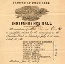
| Date: | 06 27 1839 |
|---|---|
| Description: | Invitation for Darwin Clark to the Independence Ball on the 4th of July, 1839 at the American Hotel. |

| Date: | 1836 |
|---|---|
| Description: | The top map is the "Plat of Madison the Capitol of Wisconsin." The bottom map is the "Map of the Four Lake Country. Taken from the Township Maps in the U.S... |

| Date: | 07 01 1836 |
|---|---|
| Description: | Original plat map of the town of Madison on the four lakes. |

| Date: | 1837 |
|---|---|
| Description: | Photographic print of an amateur painting, probably representing the "first house in Madison, Wisconsin." The Peck Cabin, one of the many free variations o... |
If you didn't find the material you searched for, our Library Reference Staff can help.
Call our reference desk at 608-264-6535 or email us at: