 Filter: Creator Name of Unknown
Filter: Year of 1800-1899
Filter: Year of 1800-1809
Filter: Creator Name of Unknown
Filter: Year of 1800-1899
Filter: Year of 1800-1809
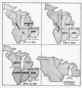
| Date: | 01 11 1805 |
|---|---|
| Description: | Four map illustrations showing the political subdivisions of the Northwest Territory from 1805 through 1834. |

| Date: | 1800 |
|---|---|
| Description: | Needlework scene on silk worked in colored silk thread using running and crewel stitches. The hands and faces of the figures are watercolor on paper. Sce... |
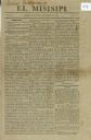
| Date: | 10 12 1808 |
|---|---|
| Description: | Front page (page 1) of the newspaper El Misisipi. Earliest Spanish-language periodical published in the United States. |
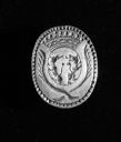
| Date: | 1801 |
|---|---|
| Description: | A silver letter seal, which belonged to Charles Langlade. |
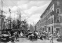
| Date: | 1800 |
|---|---|
| Description: | An illustration depicting an early scene at the wharf in New York City. Many sailing ships are along the left side of the illustration, and "Leeds" is the ... |
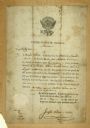
| Date: | 05 03 1804 |
|---|---|
| Description: | A certificate, signed by Joseph Wilson, that officially declares Matthias Varina a citizen of the United States of America. |

| Date: | 1800 |
|---|---|
| Description: | This 19th-century manuscript map of the Town of Newton, Manitowoc County, Wisconsin, shows sections, lakes and streams, the trail from Chicago to Green Bay... |
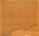
| Date: | 1800 |
|---|---|
| Description: | Map of what may be residential plots on the lake near Pheasant Branch. Streets begin top to bottom with Lake Street and going up to 14th Avenue. Streets ru... |

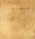
| Date: | 1800 |
|---|---|
| Description: | Ink on tracing cloth. Shows property owners in block 69, between Fourth and Third Street. |

| Date: | 1800 |
|---|---|
| Description: | Map of additions to Milwaukee. Several of the additions are outlined in colors and many streets, waterways, and some landmarks are labelled. |

| Date: | 1800 |
|---|---|
| Description: | Ink and watercolor on tracing paper. Shows plat of town, local streets, Fond du Lac River, and part of Lake Winnebago. |

| Date: | 1800 |
|---|---|
| Description: | An ink on paper map for a plan of mounds in Milwaukee county. The map is situated pointing north. |
| Date: | 1800 |
|---|---|
| Description: | Ink and pencil on paper. A paper city on the site of what is now Appleton, Wisconsin. Shows plat of city, streets, and Fox River. Includes textual descript... |

| Date: | 1800 |
|---|---|
| Description: | The map is ink and pencil on paper. Map shows the location of the Ashland Lumber Company as well as a portion of Ashland County. Portions of the map are in... |

| Date: | 1800 |
|---|---|
| Description: | This map on two sheets shows a group of ancient mounds near the southeast corner of the city of Beloit and a group of ancient mounds north of Rockton Stati... |

| Date: | 1800 |
|---|---|
| Description: | This map of North La Crosse is ink and pencil on paper and shows lot ownership and buildings. |

| Date: | 1800 |
|---|---|
| Description: | This map of the Little Kaukalin Region is ink on paper and shows Little Kaukalin Rapids, Black Bird Island, buildings, trails, meadows and woods, and a sug... |
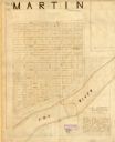
| Date: | 1800 |
|---|---|
| Description: | This map is pencil and ink on tracing cloth. The map shows plat of the town and local streets. There are some manuscript annotations in pencil and red ink. |

| Date: | 1800 |
|---|---|
| Description: | This map shows the land claim owned by the Portage Canal Company and includes an index of landownership and landmarks. The Wisconsin and Portage River, the... |

| Date: | 1800 |
|---|---|
| Description: | This map is pencil on tracing paper and shows marshes, the Wisconsin River, Indian trails, and Indian boundary line. The upper left corner reads: "Let sect... |
If you didn't find the material you searched for, our Library Reference Staff can help.
Call our reference desk at 608-264-6535 or email us at: