 Filter: Community of Aztalan
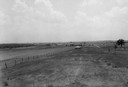
| Date: | |
|---|---|
| Description: | View of Aztalan State Park site when it was called Aztalan Mound Park. |
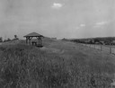
| Date: | |
|---|---|
| Description: | Pavilion in the park is on left, with a fence along the right. |
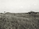
| Date: | 1935 |
|---|---|
| Description: | View of the site when it was known as Aztalan Mound Park or Aztalan Mounds, near Lake Mills. There is a pavilion in the right background. |

| Date: | 06 1973 |
|---|---|
| Description: | Fifth-graders from Mayville Public School celebrate the end of the school year by running down the earthen mounds at Aztalan State Park. Teachers on the tr... |

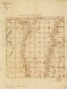
| Date: | 1837 |
|---|---|
| Description: | Copy of N.F. Hyer's original map of Aztalan as published in the Milwaukee Advertiser, February 25, 1837. |
| Date: | 1860 |
|---|---|
| Description: | This manuscript map shows the surveyed areas of the Town of Aztalan, Jefferson County, Wisconsin. Acreage of the surveyed parcels is given and lakes and st... |

| The Genesis of Modern Wisconsin |
|---|
| Discovery the history of the Woodland and Middle Mississippean Indian cultures and their relationship to modern Wisconsin. |
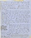
| Date: | 06 28 1850 |
|---|---|
| Description: | Letter from Increase Lapham to his wife, Ann Maria Alcott, in Milwaukee. Lapham was at Aztalan and wrote to Anna regarding the geology of the region. He in... |
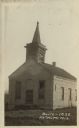
| Date: | 1910 |
|---|---|
| Description: | Photographic postcard of a three-quarter view of the exterior of an abandoned church. There are broken shutters in the belfry and a broken window in front.... |

| Date: | |
|---|---|
| Description: | Photographic postcard view from shoreline of an old bridge over the Rock River. Caption reads: "Old Bridge, Aztalan, Wis." |

| Date: | |
|---|---|
| Description: | Photographic postcard view of one of the Indian mounds at Aztalan State Park. Steps lead up to the top of the mound from the right, and a tall fence is beh... |

| Date: | |
|---|---|
| Description: | Photographic postcard view of three views from Aztalan State Park; Indian Mound at sunset, pottery, and a fence. |

| Date: | 1940 |
|---|---|
| Description: | This map of Aztalan is pencil and ink on paper. The map shows streets, local businesses, churches, houses, and the Crawfish River. The map reads: "Informat... |

| Date: | 09 01 1919 |
|---|---|
| Description: | Photographic postcard view of a river, with part of an outbuilding in the foreground on the left. On the opposite shoreline is a farm, with farmhouse, barn... |
| Community: | Aztalan |
|---|---|
| County: | Jefferson |
| Historic Name: | EAST AZTALAN SCHOOL |
| Reference Number: | 118287 |
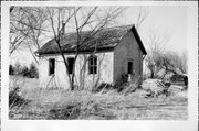
| Community: | Aztalan |
|---|---|
| County: | Jefferson |
| Historic Name: | C LANG HOUSE |
| Reference Number: | 118288 |

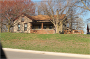
| Community: | Aztalan |
|---|---|
| County: | Jefferson |
| Historic Name: | AUGUST ZUPKE HOUSE |
| Reference Number: | 221483 |

| Community: | Aztalan |
|---|---|
| County: | Jefferson |
| Historic Name: | AZTALAN TOWN HALL & HIGHWAY SHOP |
| Reference Number: | 221484 |
If you didn't find the material you searched for, our Library Reference Staff can help.
Call our reference desk at 608-264-6535 or email us at:
