 Filter: Community of Green Bay
Filter: Subject of human settlements
Filter: Subject of transportation
Filter: Community of Green Bay
Filter: Subject of human settlements
Filter: Subject of transportation

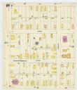
| Date: | 1907 |
|---|---|
| Description: | Sanborn map of Green Bay featuring Elm, Cedar and Main Streets. |
| Date: | 1907 |
|---|---|
| Description: | Sanborn map of Green Bay, including Harvey, Willow and Plesant Streets. |

| Date: | 1900 |
|---|---|
| Description: | This photostat map was probably originally created in 1835 and shows in addition to private claims, mills, roads, and trails. Green Bay and the Fox River a... |

| Date: | 1921 |
|---|---|
| Description: | This map shows various zones in a proposed city ordinance. Also shown are creeks, streets, parks, hospitals, cemeteries, and the Fox River. A legend is inc... |

| Date: | 04 11 1940 |
|---|---|
| Description: | This blue line print map shows survey monument markers by type and industrial buildings and covers part of the lower Fox River and East River. The map incl... |

| Date: | 1850 |
|---|---|
| Description: | This map shows the location of planned blocks and lot numbers, street names, and docks along the Fox River and canal. |

| Date: | 1917 |
|---|---|
| Description: | View over the wing of a Lawson Military Tractor 2 (MT2) in flight. Below are houses and what may be a river or lake. Location is unknown, but is probably n... |

| Date: | 1835 |
|---|---|
| Description: | Map shows the Fox River, lot and block numbers, private claims, streets, a public squares, a manual labour school, and Fort Howard. An inset map shows a pl... |

| Date: | 1900 |
|---|---|
| Description: | This set of maps contains four sheets: "Landownership in the Vicinity of Military Reserve and Fort Howard," "Houses Along the River Road to Green Bay," "Ow... |

| Date: | 1919 |
|---|---|
| Description: | Exterior view from field of a long brick Lawson plant building with a smokestack. Several automobiles are parked near the plant on the left, and on the rig... |
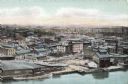
| Date: | |
|---|---|
| Description: | Aerial view of Green Bay from the bay. Commercial and industrial buildings are in the foreground. Waterfront businesses include F. Hurlbut Cement and W.W. ... |
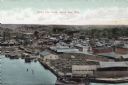
| Date: | |
|---|---|
| Description: | Bird's-eye view of Green Bay from the waterfront, with commercial buildings and factories. Caption reads: "Bird's Eye View, Green Bay, Wis." |

| Date: | 1912 |
|---|---|
| Description: | View from street towards the old city hall. The building is of brick and stone, with columns above the arched entrance. Caption reads: "City Hall, Green Ba... |
| Date: | 1909 |
|---|---|
| Description: | View of the Cook Hotel, a four-story building with wrought iron balconies. Caption reads: "Cook Hotel, Green Bay, Wis." |
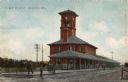
| Date: | 1909 |
|---|---|
| Description: | View of the train depot with a clock tower. Men are gathered on the platform. |
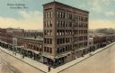
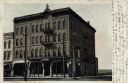
| Date: | |
|---|---|
| Description: | Elevated view of the Wilner Building, with six stories of commercial space. A clothing store is on the ground floor, and Northwestern Mutual Life Insurance... |

| Date: | |
|---|---|
| Description: | Color postcard of a domed sports and concert venue. A parking lot is in the front. |
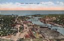
| Date: | |
|---|---|
| Description: | Aerial view of Green Bay, and the Fox River headed toward the bay. Commercial and industrial buildings are on the right bank, and residential neighborhoods... |

| Date: | |
|---|---|
| Description: | Elevated view of the Fox River at Green Bay. Warehouses and factories are along the riverfront, and a drawbridge is spanning the river in the background. |
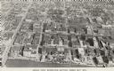
| Date: | 1956 |
|---|---|
| Description: | Caption reads: "Aerial View, Downtown Section, Green Bay, Wis." Text on reverse reads: "This aerial view shows the downtown district of the east side of ... |
If you didn't find the material you searched for, our Library Reference Staff can help.
Call our reference desk at 608-264-6535 or email us at: