 Filter: Community of Green Bay
Filter: Subject of human settlements
Filter: Community of Green Bay
Filter: Subject of human settlements
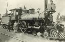
| Date: | 1896 |
|---|---|
| Description: | Railroad employees pose with locomotive engine no. 925 of the Chicago, Milwaukee & St. Paul Railway. The engine has a long pilot, a large oil headlight, sm... |

| Date: | 1957 |
|---|---|
| Description: | Large Letter style postcard for Green Bay depicting various scenes in the letters that spell the name of the city. Caption reads: "Greetings from Green Bay... |
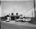
| Date: | 06 08 1959 |
|---|---|
| Description: | Exterior view of Noel's Bait and Sport Shop with cars parked in the lot in front of the building. Fishing nets can be seen on display in the window. The bu... |
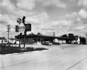
| Date: | 09 25 1957 |
|---|---|
| Description: | Exterior view from road of Sneezer's Snack Shop with two cars in the parking lot. The neon sign features a chef holding a hamburger on a plate. |

| Date: | 10 13 1919 |
|---|---|
| Description: | Exterior view of an International Harvester Green Bay branch office building. What appears to be an Auto Wagon and other automobiles are in the display win... |
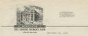
| Date: | |
|---|---|
| Description: | Letterhead of the Farmers Exchange Bank of Green Bay, Wisconsin, with a three-quarter view of the bank building and people walking on the sidewalk. There a... |

| Date: | |
|---|---|
| Description: | Memohead of the Henry Rahr Sons' Company of Green Bay, Wisconsin, brewers and maltsters, with an elevated view of the main office at 1317-1323 Main St. on ... |

| Date: | 1835 |
|---|---|
| Description: | Ink on tracing paper map of Green Bay, Wisconsin and nearby areas, Lake Winnebago, Fox and Wolf Rivers, and the junctions of the Mississippi and Wisconsin ... |

| Date: | 1914 |
|---|---|
| Description: | This map is a photostat copy from the original 1829 map in the War Department. The map shows location of Fort Howard, lots, land claims of Jacques Porlier ... |

| Date: | |
|---|---|
| Description: | This 19th century manuscript map shows lots and acreages in northern Green Bay, Wisconsin, east of the Fox River. "Preble Township, Brown County, Wis." is ... |

| Date: | 1836 |
|---|---|
| Description: | This manuscript shows the 1835 survey of the road corresponding approximately to a portion of County Trunk A in the Town of Scott, Brown County, Wisconsin.... |

| Date: | 08 27 1825 |
|---|---|
| Description: | Map is ink on paper. Map shows plat of the town of Munnomunne, the Fox River, farm lots, and an established highway. The map is signed by "J.D. Doty, Propr... |
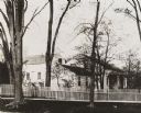
| Date: | 1900 |
|---|---|
| Description: | View from across street of the Whitney House. A man stands in the yard behind the fence. There are large trees along the curb, and more trees and shrubs in... |
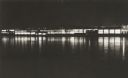
| Date: | 1957 |
|---|---|
| Description: | Long, low industrial building (factory?), probably in Green Bay, Wis., at night, from across the river, with reflections of interior lighting. |

| Date: | 1836 |
|---|---|
| Description: | This map of Navarino shows a development plat of the village situated opposite Fort Howard at mouth of the Fox River. The names of proprietors are listed a... |

| Date: | 1900 |
|---|---|
| Description: | This map of Green Bay shows plat of the town, lots by number, local streets, the military Fort Howard, part of Fox River and part of Navarino. The map feat... |

| Date: | 1974 |
|---|---|
| Description: | This map shows roads, highways, railroads, major arterials, towns, parks, recreational areas, and parts of Fox River and bay of Green Bay. The map includes... |

| Date: | 1856 |
|---|---|
| Description: | This map shows a plat of town, local streets, and parts of East and Fox Rivers. |

| Date: | 1868 |
|---|---|
| Description: | This map shows land ownership by name, lots, roads, railroads, and part of the Fox River. The map includes an explanation and table of witnesses to the cor... |

| Date: | 1930 |
|---|---|
| Description: | This map shows a plat of the town, local streets, railroads, creeks, part of Fox River, and part of the bay of Green Bay. The location of the original fort... |
If you didn't find the material you searched for, our Library Reference Staff can help.
Call our reference desk at 608-264-6535 or email us at: