 Filter: Community of Green Bay
Filter: Subject of transportation
Filter: Community of Green Bay
Filter: Subject of transportation

| Date: | 1950 |
|---|---|
| Description: | This map shows portions of highway remaining unchanged, proposed relocations, connecting county trunk roads existing or proposed, existing arterials, and e... |
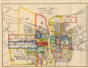
| Date: | 1956 |
|---|---|
| Description: | This map shows streets and railroads and is oriented with north to the upper left. Wards have been outlined in yellow, red, blue, and green. The back of th... |

| Date: | 1914 |
|---|---|
| Description: | This map has relief shown by hachures and shows local streets, wards, districts, railroads, Fox River, and part of Bay of Green Bay. Wards are shown in dar... |
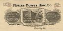
| Date: | |
|---|---|
| Description: | Letterhead of the Morley-Murphy Hardware Company, with a three-quarter view of the company building and horse, streetcar, and rail traffic around it. |

| Date: | 1874 |
|---|---|
| Description: | This map shows streets, buildings, railroads, the Fox River, the East River, and part of Green Bay. |

| Date: | 1906 |
|---|---|
| Description: | This map shows streets, railroads, land use, public buildings, commercial businesses, and the Menominee River. Depths are shown by gradient tints and sound... |

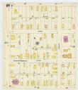
| Date: | 1907 |
|---|---|
| Description: | Sanborn map of Green Bay including St. George and Main Streets. |

| Date: | 1907 |
|---|---|
| Description: | Sanborn map of Green Bay featuring Elm, Cedar and Main Streets. |
| Date: | 1907 |
|---|---|
| Description: | Sanborn map of Green Bay, including Harvey, Willow and Plesant Streets. |

| Date: | 1900 |
|---|---|
| Description: | This photostat map shows private claim owners, natural meadows, roads, saw and grist mills, and Fort Howard. The upper right corner includes annotations an... |

| Date: | 1900 |
|---|---|
| Description: | This photostat map was probably originally created in 1835 and shows in addition to private claims, mills, roads, and trails. Green Bay and the Fox River a... |

| Date: | 1921 |
|---|---|
| Description: | This map shows various zones in a proposed city ordinance. Also shown are creeks, streets, parks, hospitals, cemeteries, and the Fox River. A legend is inc... |

| Date: | 04 11 1940 |
|---|---|
| Description: | This blue line print map shows survey monument markers by type and industrial buildings and covers part of the lower Fox River and East River. The map incl... |

| Date: | 1850 |
|---|---|
| Description: | This map shows the location of planned blocks and lot numbers, street names, and docks along the Fox River and canal. |

| Date: | 1917 |
|---|---|
| Description: | Photographic postcard of the pump double inlet pipe for a Lawson Military Tractor 2 (MT2). Some further details of the engine are visible as well. |
| Date: | 1917 |
|---|---|
| Description: | Detail of the wing assembly on a Lawson Military Tractor 2 (MT2). |

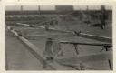
| Date: | 1917 |
|---|---|
| Description: | Man standing next to a Lawson Military Tractor 2 (MT2). The man is wearing a coverall worksuit and has a mustache and undercut haircut. |
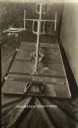
| Date: | 1917 |
|---|---|
| Description: | Rear view of the control mechanism for a Lawson Military Tractor 2 (MT2). |
| Date: | 1917 |
|---|---|
| Description: | Throttle control on a Lawson Military Tractor 2 (MT2). |

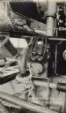
| Date: | 1917 |
|---|---|
| Description: | Detail of the stick control mechanism on a Lawson Military Tractor 2 (MT2). |
If you didn't find the material you searched for, our Library Reference Staff can help.
Call our reference desk at 608-264-6535 or email us at: