 Filter: Community of Milwaukee
Filter: Subject of tourism
Filter: Community of Milwaukee
Filter: Subject of tourism

| Date: | |
|---|---|
| Description: | A tour boat with many passengers is traveling down a river. Two boys are sitting on the roof with suitcases and other baggage, and two men wearing hats are... |

| Date: | 1940 |
|---|---|
| Description: | Shows Milwaukee and Waukesha counties, and parts of Dodge, Washington, Ozaukee, Jefferson, Walworth, and Racine counties. Includes indexes of "Cities, Town... |

| Date: | 1956 |
|---|---|
| Description: | Intended for tourists, this brochure features a map of Milwaukee's central business district as well as general information about parking, beaches and othe... |
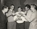
| Date: | 1953 |
|---|---|
| Description: | William R. "Bill" Kinney (1912-1978; second from left) and friends enjoy a beer at the Miller Brewery. Bill and his brother Howard Kinney owned the White F... |

| Date: | 1942 |
|---|---|
| Description: | This map shows the route of the Milwaukee Road, roads, foot trails, resorts, and ranger stations. The map includes text, illustrations, a railroad fare tab... |
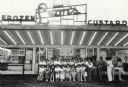
| Date: | 1980 |
|---|---|
| Description: | View across parking lot towards a group of Japanese woman posing in front of Leon's Frozen Custard. Caption reads: "Visiting Japanese students posed in fro... |
If you didn't find the material you searched for, our Library Reference Staff can help.
Call our reference desk at 608-264-6535 or email us at: