 Filter: Community of Sturgeon Bay
Filter: Subject of human settlements
Filter: Type of Map or Atlas
Filter: Community of Sturgeon Bay
Filter: Subject of human settlements
Filter: Type of Map or Atlas

| Date: | 1893 |
|---|---|
| Description: | Bird's-eye map of Sturgeon Bay, looking Northeast. Area bordered by Church Street in top left corner, leather & Smith Bridge in bottom left corner, Lawrenc... |

| Date: | 1880 |
|---|---|
| Description: | Bird's-eye map of Sturgeon Bay. County Seat of Door County. |

| Date: | 1899 |
|---|---|
| Description: | Map of Door County with inset photograph of Sturgeon Bay City. |

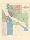
| Date: | 1943 |
|---|---|
| Description: | This map of Sturgeon Bay shows section and quarter corners, ward divisions, government building locations, roads, and railroads. The map includes a legend ... |

| Date: | 1950 |
|---|---|
| Description: | This map of Sturgeon Bay is part of the survey of the northern and northwestern lakes. The map shows lights, railroads, roads, and some public buildings. R... |

| Date: | 06 25 1901 |
|---|---|
| Description: | This map shows beacons, buoys, docks, quarries, streets, and buildings. The map inset shows the Harbor of refuge at entrance to Sturgeon Bay and Lake Michi... |

| Date: | 12 28 1908 |
|---|---|
| Description: | This map shows beacons, buildings, streets, and quarries. Two inset maps include: Vicinity of Sturgeon Bay, Wis. and the Harbor of refuge at entrance to St... |
| Date: | 1961 |
|---|---|
| Description: | This map shows zoning districts, wards, and house number system and is indexed for points of interest. The upper right corner includes a color coded zoning... |
If you didn't find the material you searched for, our Library Reference Staff can help.
Call our reference desk at 608-264-6535 or email us at: