Filter: County of Dodge
Filter: Creator Name of Unknown
Filter: Subject of land
Filter: County of Dodge
Filter: Creator Name of Unknown
Filter: Subject of land
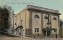
| Date: | 1912 |
|---|---|
| Description: | Exterior view of the Davison Theater. Caption reads: "Davison Theatre, Beaver Dam, Wis." |
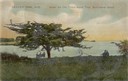
| Date: | |
|---|---|
| Description: | Three people sitting on a bench under the old thorn apple tree at Schliewerts Island looking out at the lake. Caption reads: "Beaver Dam, Wis. Under the Ol... |

| Date: | 1905 |
|---|---|
| Description: | View from shoreline towards a river with a dam in the distance. Caption reads: "River Scene, Mayville, Wis." |
| Date: | |
|---|---|
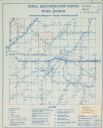
| Description: | Rural electrification map of Dodge county in Elba township. Title at top reads: "Rural Electrification Survey by Work Division of Wisconsin Emergency Relie... |

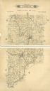
| Date: | 1910 |
|---|---|
| Description: | Left half of a plat map of Hustisford in Dodge County. |

| Date: | 1910 |
|---|---|
| Description: | The right half of a plat map of Hustisford in Dodge County. |

| Date: | 1937 |
|---|---|
| Description: | Label submitted to the state of Wisconsin for trademark registration. "Pioneer Beer, G. Weber Brewing Co." Under this in the center is a leaf with the lett... |

| Date: | |
|---|---|
| Description: | Colorized postcard view over water towards boats and boaters at a resort. In the background are people and boats near a pier. The resort is among trees on ... |

| Date: | 1870 |
|---|---|
| Description: | This map is ink and color on tracing cloth and shows Iron Ridge, the hotel and saw mill at Iron Ridge Village, Milwaukee & St. Paul Railway, plank road, an... |

| Date: | 1846 |
|---|---|
| Description: | This map is paint and ink on board with relief shown pictorially. The map was planned by Alfred Ames, drawn by one daughter and painted by another daughter... |
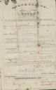
| Date: | 01 29 1853 |
|---|---|
| Description: | Document of agreement between Oren Johnson of Dodge County and the La Crosse and Milwaukee Rail Road Company. Johnson agreed to pay $600 plus 8% annual int... |
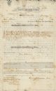
| Date: | 07 09 1853 |
|---|---|
| Description: | Legal title to Oren Johnson's mortgaged land in Dodge County. The La Crosse and Milwaukee Rail Road Company assessed the land for $1,500. |

| Date: | 1913 |
|---|---|
| Description: | View across water towards Elmwood Island, with lakeside homes. Caption reads: "Elmwood Island at Fox Lake, Wis." |

| Date: | 1915 |
|---|---|
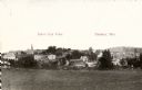
| Description: | View of the Upper Dam on the Rock River near Mayville. A church is on the hill on the left. Caption reads: "Upper Dam, Mayville, Wis." |
If you didn't find the material you searched for, our Library Reference Staff can help.
Call our reference desk at 608-264-6535 or email us at: