Filter: County of Dodge
Filter: Subject of agriculture
Filter: Subject of land
Filter: County of Dodge
Filter: Subject of agriculture
Filter: Subject of land
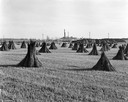
| Date: | 1943 |
|---|---|
| Description: | Field of shocked hemp with stock pile, and the J. Leroy Farmer Hemp Mill in the background. |
| Date: | 2004 |
|---|---|
| Description: | The 6th generation of Keups now live on this farm. The property was purchased by David Keup in 1867. It was passed on to Martin, Herman, William, and now G... |
| Date: | 2004 |
|---|---|
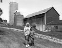
| Description: | Pam Donald and her children, Joey, Jimmy and Mary, live at N8914 N. Pole Road (Section 11). |
| Date: | 2004 |
|---|---|
| Description: | Karen Huettner and son, Kevin, live at N7561 Hwy 175 (Section 36). |
| Date: | 2004 |
|---|---|
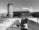
| Description: | The Donald property is located on a very high hill. The old silo dates to 1911. The Department of Natural Resources owns and uses the old barn. |

| Date: | 2004 |
|---|---|
| Description: | About 40 elk are currently being raised on the Enderle farm by Tim Enderle. |
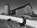
| Date: | 2004 |
|---|---|
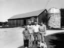
| Description: | Todd and Mary Alice Bodden, Matthew (14) and Thomas (10), live at N8202 Hwy 175 (Section 23). This barn has been in the Bodden family since 1851. |
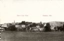
| Date: | 1909 |
|---|---|
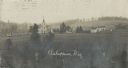
| Description: | Elevated view of a church with cemetery and farmhouses and rolling hills in the distance. Caption reads: "Ashippun, Wis." |
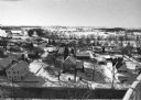
| Date: | 02 02 1978 |
|---|---|
| Description: | "Water tower view, looking due west." |
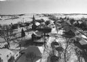
| Date: | 02 02 1978 |
|---|---|
| Description: | "Groundhog Day... A view from the water tower, looking northwest. The 20mm lens provides a very wide angle of view." |
| Date: | 02 02 1978 |
|---|---|
| Description: | "Water tower view, looking to the east." |
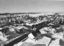
| Date: | 02 02 1978 |
|---|---|
| Description: | "A view from the water tower, looking due south. Groundhog Day was a cloud-free day; forecasting six more weeks of bad weather." |
| Date: | 02 02 1978 |
|---|---|
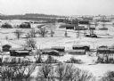
| Description: | "The camera looks to the new subdivision and beyond." |

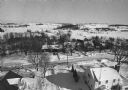
| Date: | 02 16 1978 |
|---|---|
| Description: | "The long lens compresses this view from the frozen Rock River in the foreground, the Catholic cemetery, and the Haag farm buildings in the distance." |

| Date: | 02 1978 |
|---|---|
| Description: | Elevated view of the town's elaborate brick church featuring a central steeple. |

| Date: | |
|---|---|
| Description: | "Kay & Brenda Widmer pause on a high hill on McArthur Road southwest of Theresa." |

| Date: | 1962 |
|---|---|
| Description: | "This is Doyle Road, looking north, near where it intersects with Allen Road." Taken through the windsheild of the photograhper's car. |
If you didn't find the material you searched for, our Library Reference Staff can help.
Call our reference desk at 608-264-6535 or email us at: