Filter: County of Dodge
Filter: Subject of agriculture
Filter: Subject of water
Filter: County of Dodge
Filter: Subject of agriculture
Filter: Subject of water

| Date: | |
|---|---|
| Description: | View of the Van Brunt plant. The Van Brunt Manufacturing Company began in 1860 when brothers George and Daniel Van Brunt patented a design for a combinatio... |
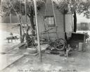
| Date: | 1923 |
|---|---|
| Description: | View of what appears to be a water pump powered by an International Harvester stationary engine on the farm of Albert Guenther. |
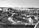
| Date: | 02 02 1978 |
|---|---|
| Description: | "Water tower view, looking due west." |
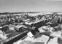
| Date: | 02 02 1978 |
|---|---|
| Description: | "Groundhog Day... A view from the water tower, looking northwest. The 20mm lens provides a very wide angle of view." |
| Date: | 02 24 1978 |
|---|---|
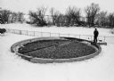
| Description: | "Theresa Waste Disposal System. Village man, Jim Zillmer, checks out sprinkler system." |

| Date: | 02 16 1978 |
|---|---|
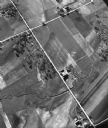
| Description: | "The long lens compresses this view from the frozen Rock River in the foreground, the Catholic cemetery, and the Haag farm buildings in the distance." |
| Date: | 06 16 1949 |
|---|---|
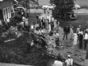
| Description: | "This crop dusting plane crashed and burned on the Lucy Firk's property on the north end of the village." |

| Date: | 07 19 1949 |
|---|---|
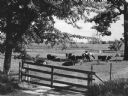
| Description: | "Cows graze along the Rock River southeast of Theresa." |

| Date: | 03 12 1950 |
|---|---|
| Description: | "This little brook is located near Raccoon Road." |

| Date: | |
|---|---|
| Description: | "Cows graze along the Rock River. In the distance is North Pole Road and beyond that tracks of the Soo Line Railroad." |
| Date: | 1964 |
|---|---|
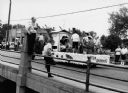
| Description: | "Mayville photographer, Edgar G. Mueller, covers a parade in Theresa." |
| Date: | 1966 |
|---|---|
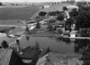
| Description: | "This view is from St. Theresa Catholic Church. Looking north toward Zimmel Implement." |
| Date: | 05 30 1967 |
|---|---|
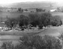
| Description: | View of a parade traveling through a cemetery. Beyond, barns and farmhouses can be seen. |
| Date: | 05 1948 |
|---|---|
| Description: | "This shows where Cty Trk P & Hochheim Rd intersect. A small creek cuts through the Wm Kemp Farm." |

| Date: | 04 1951 |
|---|---|
| Description: | "The camera looks south on the bridge on North Pole Rd." |
| Date: | 08 1982 |
|---|---|
| Description: | "These cows were photographed on the Myron Wenninger farm on County D." |

| Date: | 06 1988 |
|---|---|
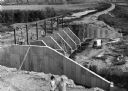
| Description: | "This photo of the pipeline looks north on the Larry Luhn farm. The opposite looks south from the same point on the farm." |
If you didn't find the material you searched for, our Library Reference Staff can help.
Call our reference desk at 608-264-6535 or email us at: