Filter: County of Dodge
Filter: Subject of church buildings
Filter: Subject of roads
Filter: County of Dodge
Filter: Subject of church buildings
Filter: Subject of roads

| Date: | 1867 |
|---|---|
| Description: | Birds-eye drawing of Beaver Dam, Dodge Co., depicting street names and street layout, houses, rivers, lakes, and trees. A reference key at the bottom of th... |
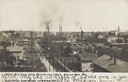
| Date: | 1905 |
|---|---|
| Description: | Caption reads: "Birds Eye View, from cotton mill tower, Beaver Dam, Wis." Two churches are in the background, and there are smokestacks and a water tower n... |

| Date: | |
|---|---|
| Description: | Colorized view down Main Street. Caption reads: "Main Street, East, Horicon, Wis." |

| Date: | 02 01 1978 |
|---|---|
| Description: | "In the early morning hours, a new month dawns on the small village of Theresa. The village is now in the 130th year of its existence." The village marke... |

| Date: | 02 24 1978 |
|---|---|
| Description: | "School children boarding bus #14 after school." |

| Date: | 02 16 1978 |
|---|---|
| Description: | "Carrying the casket from Zion, the small country church." |

| Date: | 1966 |
|---|---|
| Description: | "This view is from St. Theresa Catholic Church. Looking north toward Zimmel Implement." |

| Date: | 05 1987 |
|---|---|
| Description: | "Runners turned the corner at the intersection of McArthur Road & Bancroft Road." |

| Date: | 04 1994 |
|---|---|
| Description: | "This photo was taken from the silo on the Craig and Judy Hahn Farm." |

| Date: | 06 1994 |
|---|---|
| Description: | "Immanuel Lutheran 'River' Church on Hwy AY." |

| Date: | 1896 |
|---|---|
| Description: | This late 19th-century map of Dodge County, Wisconsin, shows the township and range grid, towns, sections, cities, villages and post offices, some property... |

| Date: | 1899 |
|---|---|
| Description: | This 1899 map of Dodge County, Wisconsin, shows the township and range grid, towns, sections, cities and villages, roads, railroads, post offices, cemeteri... |
If you didn't find the material you searched for, our Library Reference Staff can help.
Call our reference desk at 608-264-6535 or email us at: