Filter: County of Dodge
Filter: Subject of intellectual life
Filter: Subject of land
Filter: County of Dodge
Filter: Subject of intellectual life
Filter: Subject of land

| Date: | 1885 |
|---|---|
| Description: | Bird's-eye map of Hustisford. |
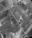
| Date: | 05 1948 |
|---|---|
| Description: | "This shows where Cty Trk P & Hochheim Rd intersect. A small creek cuts through the Wm Kemp Farm." |

| Date: | 1949 |
|---|---|
| Description: | "Jayne Blodgett - Conover Model." A photographer with a 4x5 press camera is shooting from the opposite direction. |
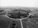
| Date: | 09 1996 |
|---|---|
| Description: | "As you look north, North Pole Road intersects DD. At the right is Theresa Station." |
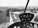
| Date: | 09 1996 |
|---|---|
| Description: | "As we approach Firemen's Park, we are at the end of our ride." |
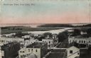
| Date: | 1912 |
|---|---|
| Description: | Bird's-eye view of downtown Fox Lake, with a marshy area and the lake in the background. Caption reads: "Bird's-eye View, Fox Lake, Wis." |
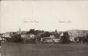
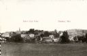
| Date: | 1907 |
|---|---|
| Description: | Text on front reads: "Bird's Eye View. Theresa, Wis." Elevated view of the town from a field. Homes, farms, businesses and churches can be seen with hills ... |
If you didn't find the material you searched for, our Library Reference Staff can help.
Call our reference desk at 608-264-6535 or email us at: