 Filter: County of Dodge
Filter: Subject of lakes
Filter: Subject of land
Filter: County of Dodge
Filter: Subject of lakes
Filter: Subject of land
| Date: | |
|---|---|
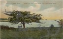
| Description: | Three people sitting on a bench under the old thorn apple tree at Schliewerts Island looking out at the lake. Caption reads: "Beaver Dam, Wis. Under the Ol... |

| Date: | 1910 |
|---|---|
| Description: | Left half of a plat map of Hustisford in Dodge County. |

| Date: | 1896 |
|---|---|
| Description: | This late 19th-century map of Dodge County, Wisconsin, shows the township and range grid, towns, sections, cities, villages and post offices, some property... |

| Date: | |
|---|---|
| Description: | Colorized postcard view over water towards boats and boaters at a resort. In the background are people and boats near a pier. The resort is among trees on ... |

| Date: | 1891 |
|---|---|
| Description: | This map shows soft marshland, water channels, solid ground, club boundary and shooting boxes. Big Lake, First Channel, Second Channel, Fout Mile Pond, Mal... |
| Date: | 1912 |
|---|---|
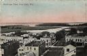
| Description: | Bird's-eye view of downtown Fox Lake, with a marshy area and the lake in the background. Caption reads: "Bird's-eye View, Fox Lake, Wis." |

| Date: | 1913 |
|---|---|
| Description: | View across water towards Elmwood Island, with lakeside homes. Caption reads: "Elmwood Island at Fox Lake, Wis." |
If you didn't find the material you searched for, our Library Reference Staff can help.
Call our reference desk at 608-264-6535 or email us at:
