Filter: County of Dodge
Filter: Subject of land
Filter: County of Dodge
Filter: Subject of land

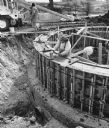
| Date: | 03 21 1997 |
|---|---|
| Description: | "The base of the new water tower is now taking shape." |

| Date: | 04 17 1997 |
|---|---|
| Description: | "Shirley Widmer poses on the now completed water tower base." |

| Date: | 04 30 1997 |
|---|---|
| Description: | "At the fire on the opposite page [Page 26], this 3/4 full, 500 gallon propane tank exploded and was propelled 1/2 mile to this location on the Jim & Donna... |

| Date: | 1997 |
|---|---|
| Description: | "Looking southeast of the water tower are Carl Benter rental units." |
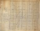
| Date: | 1867 |
|---|---|
| Description: | This manuscript map shows the township and range grid, towns, and sections in Dodge County, Wisconsin. |

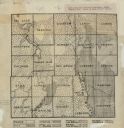
| Date: | 1896 |
|---|---|
| Description: | This late 19th-century map of Dodge County, Wisconsin, shows the township and range grid, towns, sections, cities, villages and post offices, some property... |
| Date: | 1922 |
|---|---|
| Description: | This early 20th century manuscript map shows prairie, maple, maple and beech, marsh conifer, oak, oak and maple, and grass and sedge areas by town in Dodge... |

| Date: | 1921 |
|---|---|
| Description: | Relief shown by contours and spot heights. Includes inset location map. "Contour interval 10 feet." "Advance sheet, subject to correction." "Surveyed in 19... |

| Date: | 1852 |
|---|---|
| Description: | Map created between 1852 and 1867 shows numbered lots, labelled roads, the "Centre Line of LaCrosse & Milwaukee R.R." railroad, and a station house. Roads ... |

| Date: | |
|---|---|
| Description: | Colorized postcard view over water towards boats and boaters at a resort. In the background are people and boats near a pier. The resort is among trees on ... |

| Date: | 09 1957 |
|---|---|
| Description: | The Zastrow wedding party is shown on their way to the Mayville Park Pavilion. Locals will recognize this hill on the Mayville Road before it was leveled o... |

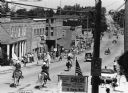
| Date: | 09 1957 |
|---|---|
| Description: | Loehrke/Zastrow wedding. The Mayville Park Pavilion is reflected in the Rock River. |

| Date: | 10 1981 |
|---|---|
| Description: | Members of the Rod and Gun Club released birds on grounds they use for hunting on the day preceding the opening of pheasant hunting season. Pictured is Chu... |

| Date: | |
|---|---|
| Description: | Elevated view of the marsh and silos under a thick fog. |

| Date: | 05 1984 |
|---|---|
| Description: | A steeplejack works on St. Peters Lutheran Church. |
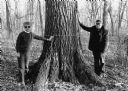
| Date: | 1986 |
|---|---|
| Description: | Shirley and Alphonse Beck are dwarfed by this large Red Oak in Beck's Woods along North Pole Road, near the Theresa Station. The tree measures 12 feet in c... |
If you didn't find the material you searched for, our Library Reference Staff can help.
Call our reference desk at 608-264-6535 or email us at: