Filter: County of Dodge
Filter: Subject of land
Filter: County of Dodge
Filter: Subject of land

| Date: | |
|---|---|
| Description: | "Kay & Brenda Widmer pause on a high hill on McArthur Road southwest of Theresa." |

| Date: | 1962 |
|---|---|
| Description: | "This is Doyle Road, looking north, near where it intersects with Allen Road." Taken through the windsheild of the photograhper's car. |

| Date: | 07 19 1949 |
|---|---|
| Description: | "Cows graze along the Rock River southeast of Theresa." |

| Date: | |
|---|---|
| Description: | View of rows of field crops surrounded by other farmland. |

| Date: | 03 12 1950 |
|---|---|
| Description: | "This little brook is located near Raccoon Road." |

| Date: | 1952 |
|---|---|
| Description: | "This waterfall is located on Hocheim Road southwest of Theresa." |

| Date: | 04 12 1949 |
|---|---|
| Description: | "These houses on Church Street were photographed from the intersection of Henni & Wisconsin Streets. Note the outhouses!" |

| Date: | |
|---|---|
| Description: | "This field is located south of Theresa." |

| Date: | |
|---|---|
| Description: | "Cows graze along the Rock River. In the distance is North Pole Road and beyond that tracks of the Soo Line Railroad." |

| Date: | 1971 |
|---|---|
| Description: | "Kay Widmer pulls her toboggan up the hill that is on the southwest edge of the village." |

| Date: | 09 1949 |
|---|---|
| Description: | "This view is straight south of Widmer Cheese Factory." |
| Date: | 1970 |
|---|---|
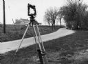
| Description: | "Surveying Crew on McArthur Rd. Sunny Brae farm is in background." |
| Date: | 05 30 1967 |
|---|---|
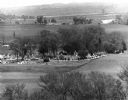
| Description: | View of a parade traveling through a cemetery. Beyond, barns and farmhouses can be seen. |

| Date: | 1963 |
|---|---|
| Description: | "The view south from St. Theresa Catholic Church." |

| Date: | 05 1948 |
|---|---|
| Description: | "This shows where Cty Trk P & Hochheim Rd intersect. A small creek cuts through the Wm Kemp Farm." |
If you didn't find the material you searched for, our Library Reference Staff can help.
Call our reference desk at 608-264-6535 or email us at: