Filter: County of Dodge
Filter: Subject of landscape
Filter: Subject of dwellings
Filter: County of Dodge
Filter: Subject of landscape
Filter: Subject of dwellings
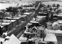
| Date: | 02 02 1978 |
|---|---|
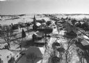
| Description: | "Water tower view, looking due west." |
| Date: | 02 02 1978 |
|---|---|
| Description: | "Groundhog Day... A view from the water tower, looking northwest. The 20mm lens provides a very wide angle of view." |
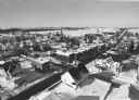
| Date: | 02 02 1978 |
|---|---|
| Description: | "Water tower view, looking to the east." |
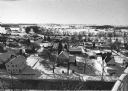
| Date: | 02 02 1978 |
|---|---|
| Description: | "A view from the water tower, looking due south. Groundhog Day was a cloud-free day; forecasting six more weeks of bad weather." |
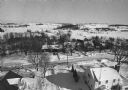
| Date: | 02 02 1978 |
|---|---|
| Description: | "The camera looks to the new subdivision and beyond." |

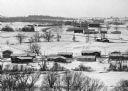
| Date: | 02 16 1978 |
|---|---|
| Description: | "The long lens compresses this view from the frozen Rock River in the foreground, the Catholic cemetery, and the Haag farm buildings in the distance." |

| Date: | |
|---|---|
| Description: | View of rows of field crops surrounded by other farmland. |

| Date: | 01 1983 |
|---|---|
| Description: | "This photo shows the John Steger home on the West Bend Road, foreground, the Willard Bogenschneider farm in the middle distance, and Theresa Station and t... |

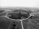
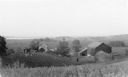
| Date: | |
|---|---|
| Description: | View of farmland featuring farmhouses, barns, and a water tower. |
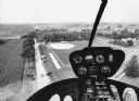
| Date: | 09 1996 |
|---|---|
| Description: | "As you look north, North Pole Road intersects DD. At the right is Theresa Station." |
| Date: | 09 1996 |
|---|---|
| Description: | "As we approach Firemen's Park, we are at the end of our ride." |

| Date: | 1846 |
|---|---|
| Description: | This map is paint and ink on board with relief shown pictorially. The map was planned by Alfred Ames, drawn by one daughter and painted by another daughter... |

| Date: | 05 1902 |
|---|---|
| Description: | Elevated view down hill towards three different farmhouses and various farm buildings spread out among fields. Text on envelope identifies it as "Gotlieb K... |

| Date: | 1903 |
|---|---|
| Description: | View down hill towards two adjoining farmsteads. |
| Date: | 1912 |
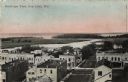
|---|---|
| Description: | Bird's-eye view of downtown Fox Lake, with a marshy area and the lake in the background. Caption reads: "Bird's-eye View, Fox Lake, Wis." |
| Date: | 1935 |
|---|---|
| Description: | Elevated view from hill of chickens ranging near their coop behind a farmhouse and outbuildings on a tidy farm. There is a large barn on the right with two... |
If you didn't find the material you searched for, our Library Reference Staff can help.
Call our reference desk at 608-264-6535 or email us at: