Filter: County of Dodge
Filter: Subject of landscape
Filter: Subject of transportation
Filter: County of Dodge
Filter: Subject of landscape
Filter: Subject of transportation

| Date: | 1885 |
|---|---|
| Description: | Bird's-eye map of Hustisford. |
| Date: | 2004 |
|---|---|
| Description: | The 6th generation of Keups now live on this farm. The property was purchased by David Keup in 1867. It was passed on to Martin, Herman, William, and now G... |

| Date: | 2004 |
|---|---|
| Description: | About 40 elk are currently being raised on the Enderle farm by Tim Enderle. |
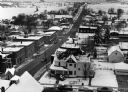
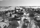
| Date: | 02 02 1978 |
|---|---|
| Description: | "Water tower view, looking due west." |
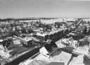
| Date: | 02 02 1978 |
|---|---|
| Description: | "Groundhog Day... A view from the water tower, looking northwest. The 20mm lens provides a very wide angle of view." |
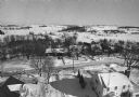
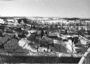
| Date: | 02 02 1978 |
|---|---|
| Description: | "Water tower view, looking to the east." |
| Date: | 02 02 1978 |
|---|---|
| Description: | "A view from the water tower, looking due south. Groundhog Day was a cloud-free day; forecasting six more weeks of bad weather." |
| Date: | 02 02 1978 |
|---|---|
| Description: | "The camera looks to the new subdivision and beyond." |

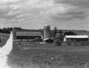
| Date: | |
|---|---|
| Description: | View of rows of field crops surrounded by other farmland. |

| Date: | 03 12 1950 |
|---|---|
| Description: | "This little brook is located near Raccoon Road." |

| Date: | |
|---|---|
| Description: | "Cows graze along the Rock River. In the distance is North Pole Road and beyond that tracks of the Soo Line Railroad." |

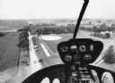
| Date: | 01 1983 |
|---|---|
| Description: | "This photo shows the John Steger home on the West Bend Road, foreground, the Willard Bogenschneider farm in the middle distance, and Theresa Station and t... |
| Date: | 09 1996 |
|---|---|
| Description: | "As you look north, North Pole Road intersects DD. At the right is Theresa Station." |
| Date: | 09 1996 |
|---|---|
| Description: | "As we approach Firemen's Park, we are at the end of our ride." |

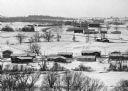
| Date: | 1903 |
|---|---|
| Description: | View down hill towards two adjoining farmsteads. |

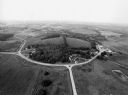
| Date: | 1955 |
|---|---|
| Description: | Elevated view from a hill towards a valley with several farms and fields. A forested hill is in the far background. |
If you didn't find the material you searched for, our Library Reference Staff can help.
Call our reference desk at 608-264-6535 or email us at: