 Filter: County of Dodge
Filter: Subject of railroads
Filter: County of Dodge
Filter: Subject of railroads

| Date: | 1867 |
|---|---|
| Description: | Birds-eye drawing of Beaver Dam, Dodge Co., depicting street names and street layout, houses, rivers, lakes, and trees. A reference key at the bottom of th... |

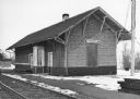
| Date: | 1915 |
|---|---|
| Description: | View down platform towards a C. M. & St. Paul train at the depot. A few men are standing on the platform. There is a water tower just behind the depot, and... |
| Date: | 02 19 1978 |
|---|---|
| Description: | "Soo Line Railroad Station. Before the days of radio, some of the local men would huddle around the telegraph key as reports came over the wire of a prize... |

| Date: | |
|---|---|
| Description: | View of a people walking on railroad tracks near a derailed train. |

| Date: | 01 1983 |
|---|---|
| Description: | "This photo shows the John Steger home on the West Bend Road, foreground, the Willard Bogenschneider farm in the middle distance, and Theresa Station and t... |

| Date: | 1896 |
|---|---|
| Description: | This late 19th-century map of Dodge County, Wisconsin, shows the township and range grid, towns, sections, cities, villages and post offices, some property... |

| Date: | 1899 |
|---|---|
| Description: | This 1899 map of Dodge County, Wisconsin, shows the township and range grid, towns, sections, cities and villages, roads, railroads, post offices, cemeteri... |

| Date: | 1852 |
|---|---|
| Description: | Map created between 1852 and 1867 shows numbered lots, labelled roads, the "Centre Line of LaCrosse & Milwaukee R.R." railroad, and a station house. Roads ... |

| Date: | 1932 |
|---|---|
| Description: | This map of Beaver Dam shows new boundary lines for wards, existing wards, roads, railroads, and rivers. Roads and Beaver Dam Lake are labeled. There are s... |

| Date: | 1868 |
|---|---|
| Description: | This map is ink on tracing cloth and shows lot and block numbers, depot, railroads and side tracks, and streets in sections 24 and 25, T.11, R.16E. The map... |

| Date: | 1870 |
|---|---|
| Description: | This map is ink and color on tracing cloth and shows Iron Ridge, the hotel and saw mill at Iron Ridge Village, Milwaukee & St. Paul Railway, plank road, an... |
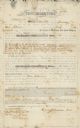
| Date: | 01 29 1853 |
|---|---|
| Description: | Document of agreement between Oren Johnson of Dodge County and the La Crosse and Milwaukee Rail Road Company. Johnson agreed to pay $600 plus 8% annual int... |
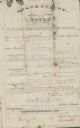
| Date: | 07 09 1853 |
|---|---|
| Description: | Legal title to Oren Johnson's mortgaged land in Dodge County. The La Crosse and Milwaukee Rail Road Company assessed the land for $1,500. |

| Date: | 05 1854 |
|---|---|
| Description: | This yellow and black wood block print broadside ties England and France's declaration of war against Russia during the Crimean War into a war against high... |
If you didn't find the material you searched for, our Library Reference Staff can help.
Call our reference desk at 608-264-6535 or email us at: