 Filter: County of Dodge
Filter: Subject of rivers
Filter: Subject of intellectual life
Filter: County of Dodge
Filter: Subject of rivers
Filter: Subject of intellectual life

| Date: | 1867 |
|---|---|
| Description: | Birds-eye drawing of Beaver Dam, Dodge Co., depicting street names and street layout, houses, rivers, lakes, and trees. A reference key at the bottom of th... |

| Date: | 1892 |
|---|---|
| Description: | This bird's-eye view map is oriented looking north-east and includes index of points of interest and businesses. The map is a photocopy. |

| Date: | 1885 |
|---|---|
| Description: | Bird's-eye map of Hustisford. |
| Date: | 1964 |
|---|---|
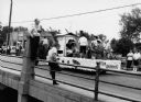
| Description: | "Mayville photographer, Edgar G. Mueller, covers a parade in Theresa." |
| Date: | 05 1948 |
|---|---|
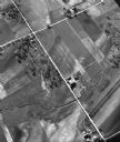
| Description: | "This shows where Cty Trk P & Hochheim Rd intersect. A small creek cuts through the Wm Kemp Farm." |

| Date: | 10 1987 |
|---|---|
| Description: | "Winfred Herberg, a perennial jokester, does a spoof on how to clean a camera lens." |

| Date: | 09 1996 |
|---|---|
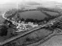
| Description: | "Theresa's Bonduel & Wisconsin Streets from the air." |
| Date: | 09 1996 |
|---|---|
| Description: | "This is Theresa Station. Note the Rock River and Soo Line Railroad track." |
| Date: | 1909 |
|---|---|
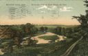
| Description: | Colorized postcard of an elevated view of a river with a dam in the distance. Caption reads: "Beaver Dam, Wis. Birds-eye View of River Below the Dam." |
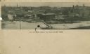
| Date: | |
|---|---|
| Description: | Aerial panoramic view of central Mayville over a frozen river. Caption reads: "All Roads Lead to Mayville, Wis." |
If you didn't find the material you searched for, our Library Reference Staff can help.
Call our reference desk at 608-264-6535 or email us at:
