 Filter: County of Dodge
Filter: Subject of rivers
Filter: Subject of land use
Filter: County of Dodge
Filter: Subject of rivers
Filter: Subject of land use

| Date: | |
|---|---|
| Description: | "These cows walked through the Rock River near the 'River Church' on County AY." |

| Date: | 07 19 1949 |
|---|---|
| Description: | "Cows graze along the Rock River southeast of Theresa." |

| Date: | 03 12 1950 |
|---|---|
| Description: | "This little brook is located near Raccoon Road." |

| Date: | |
|---|---|
| Description: | "Cows graze along the Rock River. In the distance is North Pole Road and beyond that tracks of the Soo Line Railroad." |

| Date: | 05 1948 |
|---|---|
| Description: | "This shows where Cty Trk P & Hochheim Rd intersect. A small creek cuts through the Wm Kemp Farm." |

| Date: | 04 1951 |
|---|---|
| Description: | "The camera looks south on the bridge on North Pole Rd." |

| Date: | 1976 |
|---|---|
| Description: | "Snowmobiles make their way along the Rock River." |
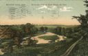
| Date: | 1909 |
|---|---|
| Description: | Colorized postcard of an elevated view of a river with a dam in the distance. Caption reads: "Beaver Dam, Wis. Birds-eye View of River Below the Dam." |

| Date: | 12 1992 |
|---|---|
| Description: | Built in 1916, the Theresa Village Dam has played a large part in the appearance of the Rock River. Dam is pictured in winter. |
| Date: | 06 1906 |
|---|---|
| Description: | Alexander and Edgar Krueger fishing along a small creek on their farm. Both have their backs to the camera, looking into the water below. |

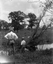
| Date: | 1912 |
|---|---|
| Description: | View from shoreline toward a bridge over the Rock River. A boat with three men is passing underneath the bridge. Caption reads: "'Wood's' Bridge South of H... |

| Date: | 1915 |
|---|---|
| Description: | View of the Upper Dam on the Rock River near Mayville. A church is on the hill on the left. Caption reads: "Upper Dam, Mayville, Wis." |

| Date: | 1910 |
|---|---|
| Description: | A land ownership map of the township of Leroy. |
If you didn't find the material you searched for, our Library Reference Staff can help.
Call our reference desk at 608-264-6535 or email us at:
