Filter: County of Dodge
Filter: Subject of rivers
Filter: County of Dodge
Filter: Subject of rivers

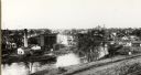
| Date: | 1907 |
|---|---|
| Description: | Buildings and storefronts in town near bridge and river. |

| Date: | 1867 |
|---|---|
| Description: | Birds-eye drawing of Beaver Dam, Dodge Co., depicting street names and street layout, houses, rivers, lakes, and trees. A reference key at the bottom of th... |

| Date: | 1892 |
|---|---|
| Description: | This bird's-eye view map is oriented looking north-east and includes index of points of interest and businesses. The map is a photocopy. |

| Date: | 1885 |
|---|---|
| Description: | Bird's-eye map of Hustisford. |

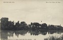
| Date: | 1905 |
|---|---|
| Description: | View from shoreline towards a river with a dam in the distance. Caption reads: "River Scene, Mayville, Wis." |
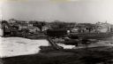
| Date: | 1900 |
|---|---|
| Description: | View of Mayville behind the frozen, snow-covered river. |

| Date: | 1910 |
|---|---|
| Description: | The right half of a plat map of Hustisford in Dodge County. |

| Date: | 02 02 1978 |
|---|---|
| Description: | "Water tower view, looking due west." |

| Date: | 02 02 1978 |
|---|---|
| Description: | "Groundhog Day... A view from the water tower, looking northwest. The 20mm lens provides a very wide angle of view." |

| Date: | 02 16 1978 |
|---|---|
| Description: | "The long lens compresses this view from the frozen Rock River in the foreground, the Catholic cemetery, and the Haag farm buildings in the distance." |
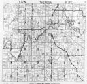
| Date: | 1952 |
|---|---|
| Description: | View of the plat map of Theresa, copyright by General Map Company, 1952. |

| Date: | |
|---|---|
| Description: | "These cows walked through the Rock River near the 'River Church' on County AY." |

| Date: | 11 09 1947 |
|---|---|
| Description: | "Ralph Widmer checked out a pier on the Rock River." Ralph was the brother of photographer Jim Widmer. |

| Date: | 1966 |
|---|---|
| Description: | "American Legion Post 270 celebrates Memorial Day." |

| Date: | 1966 |
|---|---|
| Description: | American Legion Post 270 celebrates Memorial Day. |
If you didn't find the material you searched for, our Library Reference Staff can help.
Call our reference desk at 608-264-6535 or email us at: