 Filter: County of Dodge
Filter: Subject of rivers
Filter: County of Dodge
Filter: Subject of rivers
| Date: | 1909 |
|---|---|
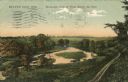
| Description: | Colorized postcard of an elevated view of a river with a dam in the distance. Caption reads: "Beaver Dam, Wis. Birds-eye View of River Below the Dam." |
| Date: | |
|---|---|
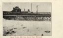
| Description: | Postcard view of a dam with a mill behind it. Caption reads: "Upper Woolen Mill Dam, Beaver Dam, Wisconsin." |
| Date: | 1916 |
|---|---|
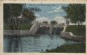
| Description: | Colorized postcard view of a dam on a river. There is a factory behind the trees in the background. Caption reads: "The New Dam, Beaver Dam, Wis." |

| Date: | 09 1957 |
|---|---|
| Description: | Loehrke/Zastrow wedding. The Mayville Park Pavilion is reflected in the Rock River. |

| Date: | 1976 |
|---|---|
| Description: | On Memorial Day American Legion Member Oliver Krueger drops a wreath into the Rock River. |

| Date: | 04 1980 |
|---|---|
| Description: | Shortly after their wedding at Saint Theresa Catholic Church, Eugene Bodden and his bride, Linda Johnson prepare to leave the church in a manure spreader. |

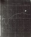
| Date: | 1932 |
|---|---|
| Description: | This map of Beaver Dam shows new boundary lines for wards, existing wards, roads, railroads, and rivers. Roads and Beaver Dam Lake are labeled. There are s... |

| Date: | 1940 |
|---|---|
| Description: | This map of Beaver Dam pictorially shows the history of the town. The map was made for the 100th anniversary celebration of Beaver Dam in 1941. The map inc... |

| Date: | 1952 |
|---|---|
| Description: | This map of Beaver Dam shows state trunk highway system, county trunk highway system, town roads, rivers, and Beaver Dam Lake and includes an additional at... |

| Date: | 12 1992 |
|---|---|
| Description: | Built in 1916, the Theresa Village Dam has played a large part in the appearance of the Rock River. Dam is pictured in winter. |

| Date: | 01 1993 |
|---|---|
| Description: | Horses and carriage at the east end of Henni Street in winter. |

| Date: | 04 1999 |
|---|---|
| Description: | With Shirley Widmer looking on, Chelsey and Logan Wilz and Parker and Carly Hren count their Easter eggs. |

| Date: | 05 1999 |
|---|---|
| Description: | 77 volunteers pick up trash and debris in the Rock River. Chuck Trauba and the crew covered the river from Theresa Marsh to the Theresa Disposal plant. 50 ... |

| Date: | 1856 |
|---|---|
| Description: | This map shows a plat of the town, local streets, lots, and part of the Rock River. The margins of the map have manuscript annotations in ink. |

| Date: | 1902 |
|---|---|
| Description: | Jennie and Edgar Krueger holding a pole between them on their shoulders, with two carp strung up on it. They are standing on a bank next to a river, with a... |
| Date: | 06 1906 |
|---|---|
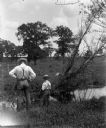
| Description: | Alexander and Edgar Krueger fishing along a small creek on their farm. Both have their backs to the camera, looking into the water below. |
| Date: | 1900 |
|---|---|
| Description: | This map shows land purchased by Solomon Juneau on Sept. 29, 1847, according to U.S. Land Office, local office tract books, Wisconsin, volume 70. Juneauvil... |

| Date: | 1891 |
|---|---|
| Description: | This map shows soft marshland, water channels, solid ground, club boundary and shooting boxes. Big Lake, First Channel, Second Channel, Fout Mile Pond, Mal... |

| Date: | 1891 |
|---|---|
| Description: | This map shows soft marshland, water channels, solid ground, club boundary and shooting boxes. Big Lake, First Channel, Second Channel, Fout Mile Pond, Mal... |

| Date: | 1900 |
|---|---|
| Description: | This map shows landownership and buildings in the community in 1876. An inset map shows Plan of Corporation of Mayville. The upper left corner includes a b... |
If you didn't find the material you searched for, our Library Reference Staff can help.
Call our reference desk at 608-264-6535 or email us at: