 Filter: County of Dodge
Filter: Subject of roads
Filter: Subject of hills
Filter: County of Dodge
Filter: Subject of roads
Filter: Subject of hills

| Date: | 2004 |
|---|---|
| Description: | About 40 elk are currently being raised on the Enderle farm by Tim Enderle. |
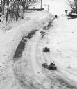
| Date: | 02 19 1978 |
|---|---|
| Description: | "Sledding on the Brewery Hill. (Top to bottom) Julie Wiedmeyer, 10, Tammy Konrath, 9, and Vicky Konrath, 7." |

| Date: | 1962 |
|---|---|
| Description: | "This is Doyle Road, looking north, near where it intersects with Allen Road." Taken through the windsheild of the photograhper's car. |

| Date: | 03 12 1950 |
|---|---|
| Description: | "This little brook is located near Raccoon Road." |

| Date: | 04 12 1949 |
|---|---|
| Description: | "These houses on Church Street were photographed from the intersection of Henni & Wisconsin Streets. Note the outhouses!" |

| Date: | |
|---|---|
| Description: | "Cows graze along the Rock River. In the distance is North Pole Road and beyond that tracks of the Soo Line Railroad." |

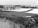
| Date: | 09 1949 |
|---|---|
| Description: | "This view is straight south of Widmer Cheese Factory." |

| Date: | 04 1951 |
|---|---|
| Description: | "Theresa firemen drill on the bridge on North Pole Rd. The camera faces north. Some of the firemen are Les Beck, Andrew Schnitzler, Armand Zimmel, & Les Zi... |
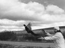
| Date: | 10 1981 |
|---|---|
| Description: | "Chuck Trauba releases pheasants on Warner Road." |
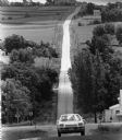
| Date: | 05 1980 |
|---|---|
| Description: | "On a hillside off McArthur Road, waste water from Widmer Cheese Factory is dumped into a ridge & furrow disposal system." |
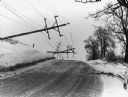
| Date: | 03 1975 |
|---|---|
| Description: | "After an ice storm, poles were down on Hwy 175, south of Theresa." |
| Date: | 03 1975 |
|---|---|
| Description: | "After the ice storm it was a mess on Doyle Road." |
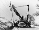
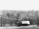
| Date: | 03 1975 |
|---|---|
| Description: | "Crews begin the cleanup after the ice storm." |
| Date: | 08 1983 |
|---|---|
| Description: | "The camera, with a long lens, looks across the valley." |

| Date: | 04 1994 |
|---|---|
| Description: | "This photo was taken from the silo on the Craig and Judy Hahn Farm." |

| Date: | 11 1995 |
|---|---|
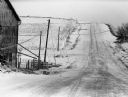
| Description: | "This view of Hwy 175 looks south with the barn of Hans Rahjes in the upper left." |

| Date: | 08 1996 |
|---|---|
| Description: | "A lone biker glides off into the distance on a misty McArthur Road." |
| Date: | 03 17 1997 |
|---|---|
| Description: | "The camera faces northeast from the water tower site." |
If you didn't find the material you searched for, our Library Reference Staff can help.
Call our reference desk at 608-264-6535 or email us at:

