 Filter: County of Dodge
Filter: Subject of water
Filter: Subject of roads
Filter: County of Dodge
Filter: Subject of water
Filter: Subject of roads

| Date: | 1867 |
|---|---|
| Description: | Birds-eye drawing of Beaver Dam, Dodge Co., depicting street names and street layout, houses, rivers, lakes, and trees. A reference key at the bottom of th... |

| Date: | 1892 |
|---|---|
| Description: | This bird's-eye view map is oriented looking north-east and includes index of points of interest and businesses. The map is a photocopy. |

| Date: | 1885 |
|---|---|
| Description: | Bird's-eye map of Hustisford. |
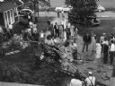
| Date: | 06 16 1949 |
|---|---|
| Description: | "This crop dusting plane crashed and burned on the Lucy Firk's property on the north end of the village." |
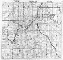
| Date: | 1952 |
|---|---|
| Description: | View of the plat map of Theresa, copyright by General Map Company, 1952. |

| Date: | 1966 |
|---|---|
| Description: | American Legion Post 270 celebrates Memorial Day. |

| Date: | 03 12 1950 |
|---|---|
| Description: | "This little brook is located near Raccoon Road." |

| Date: | |
|---|---|
| Description: | "Cows graze along the Rock River. In the distance is North Pole Road and beyond that tracks of the Soo Line Railroad." |
| Date: | 1966 |
|---|---|
| Description: | "This view is from St. Theresa Catholic Church. Looking north toward Zimmel Implement." |

| Date: | 04 1951 |
|---|---|
| Description: | "The camera looks south on the bridge on North Pole Rd." |

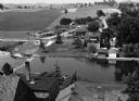
| Date: | 09 1996 |
|---|---|
| Description: | "Theresa's Bonduel & Wisconsin Streets from the air." |
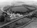
| Date: | 09 1996 |
|---|---|
| Description: | "This is Theresa Station. Note the Rock River and Soo Line Railroad track." |

| Date: | 1896 |
|---|---|
| Description: | This late 19th-century map of Dodge County, Wisconsin, shows the township and range grid, towns, sections, cities, villages and post offices, some property... |

| Date: | 1930 |
|---|---|
| Description: | This manuscript map, likely drawn in the 1930s, shows Fox Lake, in Dodge County, Wisconsin, and the roads and resorts in the vicinity. |

| Date: | 1899 |
|---|---|
| Description: | This 1899 map of Dodge County, Wisconsin, shows the township and range grid, towns, sections, cities and villages, roads, railroads, post offices, cemeteri... |
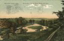
| Date: | 1909 |
|---|---|
| Description: | Colorized postcard of an elevated view of a river with a dam in the distance. Caption reads: "Beaver Dam, Wis. Birds-eye View of River Below the Dam." |

| Date: | 1932 |
|---|---|
| Description: | This map of Beaver Dam shows new boundary lines for wards, existing wards, roads, railroads, and rivers. Roads and Beaver Dam Lake are labeled. There are s... |
If you didn't find the material you searched for, our Library Reference Staff can help.
Call our reference desk at 608-264-6535 or email us at:


