 Filter: County of Dunn
Filter: Subject of architecture
Filter: Type of Map or Atlas
Filter: County of Dunn
Filter: Subject of architecture
Filter: Type of Map or Atlas
| Date: | 1927 |
|---|---|
| Description: | Shows section corners, landownership and acreages, roads, railroad, Weston village, and buildings of W.J. Starr Estate. Relief shown by hachures. "Map comp... |

| Date: | 1970 |
|---|---|
| Description: | This pictorial map of Dunn County, Wisconsin, from the 1970s depicts historical events that occurred in the county. It shows cemeteries, churches, schools,... |

| Date: | 1877 |
|---|---|
| Description: | This map is a photstat copy of the original and shows landownership, townships and sections, wagon roads, railroads, school houses, churches, cemeteries, m... |

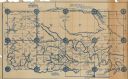
| Date: | 1907 |
|---|---|
| Description: | This blueprint map shows a proposed plan for pleasure roads and reservation system. It also shows schools, cemeteries, old river channel, proposed bridge, ... |
If you didn't find the material you searched for, our Library Reference Staff can help.
Call our reference desk at 608-264-6535 or email us at: