 Filter: County of Dunn
Filter: Subject of transportation
Filter: County of Dunn
Filter: Subject of transportation
| Date: | 1914 |
|---|---|
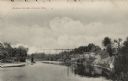
| Description: | Black and white photographic postcard looking up river towards the Wagon Bridge. Caption reads: "Wagon Bridge, Colfax, Wis." |

| Date: | 1859 |
|---|---|
| Description: | This plat map is pen on paper and shows numbered blocks and lots, local streets, and section lines. Also included is text on survey certifications. |

| Date: | 1859 |
|---|---|
| Description: | This plat map is pen on paper and shows numbered blocks and lots, local streets, and section lines. Also included is text on survey certifications. The top... |
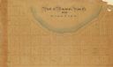
| Date: | |
|---|---|
| Description: | This plat map is pen, pencil, and watercolor on paper and shows numbered blocks and lots, local streets, section lines, the public square, Mill pond, and l... |

| Date: | 1875 |
|---|---|
| Description: | This plat map shows local streets, buildings, numbered blocks and lots, part of the Red Cedar River, and land ownership by name. Also included is a busines... |

| Date: | 1896 |
|---|---|
| Description: | This map shows plat of town, local streets, numbered blocks and lots, mill pond, mills, part of the Red Cedar River, and land and property ownership by nam... |

| Date: | 1911 |
|---|---|
| Description: | This map shows plat of town, local streets, numbered lots, blocks, and wards, roads, Lake Menomin, Wilson Creek, Red Cedar River, and land ownership by nam... |

| Date: | 1877 |
|---|---|
| Description: | This map is a photstat copy of the original and shows landownership, townships and sections, wagon roads, railroads, school houses, churches, cemeteries, m... |

| Date: | 1907 |
|---|---|
| Description: | This blueprint map shows a proposed plan for pleasure roads and reservation system. It also shows schools, cemeteries, old river channel, proposed bridge, ... |

| Date: | 1931 |
|---|---|
| Description: | This photocopy map shows lot and block numbers, some landownership and acreages, water flowage, and marshes. The map also shows Lake Menomin and Wilson Cr... |
| Date: | |
|---|---|
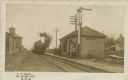
| Description: | Black and white postcard view of the depot at Elk Mound, with a train approaching. Men are standing on the platform. Caption reads: "N. W. Depot, Elk Mound... |

| Date: | 1973 |
|---|---|
| Description: | View looking up road on a hill towards trees with fall colors of yellow, orange and red leaves. |

| Date: | 1909 |
|---|---|
| Description: | Birds-eye view of Menominie, dwellings and churches. Caption reads: "Bird's-Eye View, Menomonie, Wis." |

| Date: | |
|---|---|
| Description: | Exterior view of a stone church located at 917 7th Street. |
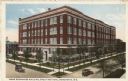
| Date: | 1917 |
|---|---|
| Description: | Slightly elevated view of the Home Economics building on a street corner. Caption reads: "Home Economics Building, Stout Institute, Menomonie, Wis." |

| Date: | 1908 |
|---|---|
| Description: | The high school building. A pedestrian bridge is on the left side of the building. Caption reads: "Central School, Menomonie, Wis." |

| Date: | |
|---|---|
| Description: | Central High School and Stout Manual Training School connected by pedestrian bridge. Two men are walking on the lawn towards the buildings. Caption reads: ... |

| Date: | 1957 |
|---|---|
| Description: | Elevated view between trees of Lake Menomin and a bridge. There are buildings among trees in the distance. Caption reads: "Lake Menomin, Menomonie, Wis." |
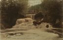
| Date: | 1910 |
|---|---|
| Description: | View looking up toward a waterfall with a footbridge spanning the top. A man is on the bridge. Caption reads: "Lambs Creek Falls near Menomonie, Wis." |

| Date: | |
|---|---|
| Description: | Elevated view of a railroad bridge spanning the Red Cedar River. Caption reads: "Red Cedar River Bridge, Menomonie, Wis." |
If you didn't find the material you searched for, our Library Reference Staff can help.
Call our reference desk at 608-264-6535 or email us at: