 Filter: County of Grant
Filter: Subject of human settlements
Filter: Subject of wisconsin river (wis.)
Filter: County of Grant
Filter: Subject of human settlements
Filter: Subject of wisconsin river (wis.)

| Date: | 1869 |
|---|---|
| Description: | Birds-eye drawing of Boscobel, Grant County, depicts street names and street layouts, houses, rivers and trees. A reference key at the bottom of the map sh... |
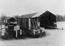
| Date: | 1935 |
|---|---|
| Description: | View of covered bridge above the Wisconsin River, 1 mile from Boscobel. |
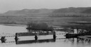
| Date: | 1933 |
|---|---|
| Description: | Elevated view of a covered railroad bridge over a calm body of water, with bluffs in the background. |
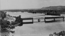
| Date: | |
|---|---|
| Description: | Elevated view of railroad bridge over the river. Part of the bridge is covered. Bluffs are in the background. |

| Date: | 1920 |
|---|---|
| Description: | Bridge over river from shoreline seen through trees in the spring or summer. Part of the bridge is covered. |

| Date: | 1920 |
|---|---|
| Description: | Aerial view of the last covered bridge, which is no longer standing. |

| Date: | 1945 |
|---|---|
| Description: | Wyalusing State Park in the Prairie du Chein vicinity. The Wisconsin River is in the foreground and the Mississippi river can be seen below with distant bl... |

| Date: | |
|---|---|
| Description: | Elevated view of the Wisconsin River. There is a bridge across the river. |

| Date: | |
|---|---|
| Description: | View from shore of a covered bridge across the Wisconsin River. |

| Date: | |
|---|---|
| Description: | Elevated view of a bridge crossing the Wisconsin River. |
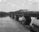
| Date: | 1920 |
|---|---|
| Description: | View of metal bridge spanning the Wisconsin River. |

| Date: | 1835 |
|---|---|
| Description: | Plat for a proposed Sinsinawa City (never built), in Grant County, Wis. When it became clear in the mid-1830s that Wisconsin Territory would be established... |

| Date: | 1920 |
|---|---|
| Description: | This 1920 map actually depicts present-day Wyalusing State Park at the confluence of the Mississippi and Wisconsin rivers in the Town of Wyalusing, Grant C... |

| Date: | |
|---|---|
| Description: | Elevated view over trees of the town of Muscoda. The water tower is in the center. The commercial district is on the left, and dwellings are in the foregro... |

| Date: | 1968 |
|---|---|
| Description: | Slightly elevated view of a family standing in front of a stone wall at Point Lookout in Wyalusing State Park. The man is pointing towards the Wisconsin Ri... |
If you didn't find the material you searched for, our Library Reference Staff can help.
Call our reference desk at 608-264-6535 or email us at: